
Pumpfields and Limekilns described as ‘vital but neglected district’

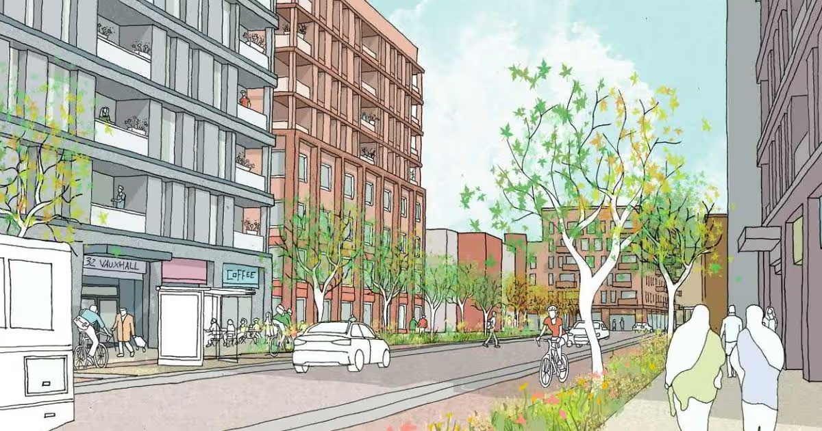
Vauxhall Road could be reimagined
More than 7,000 homes, parks and improved transport connections could be built as part of a new “transformative” masterplan for the northern edge of Liverpool city centre. Liverpool Council is to unveil its plan for the Pumpfields and Limekilns area which would be connected with the authority’s wider regeneration proposals.
Members of the local authority’s cabinet will this week be asked to endorse a strategy in the form of a supplementary planning document (SPD), that will embrace the site’s past while creating a sustainable, vibrant, mixed-use new neighbourhood delivering new homes, along with improved infrastructure and community facilities. The SPD sets out how the “vital but neglected district” represents a critical part of the jigsaw linking the heart of Liverpool to the established residential communities to the north and the emerging regeneration areas along the waterfront.
An SPD is a technical document that planning authorities can produce to provide guidance on planning policies in a Local Plan. Under the new vision outlined by Liverpool Council, the area around Pumpfields and Limekilns could become a ” highly sustainable extension of the city centre, accommodating substantial housing growth and optimising strategic economic benefits.”
The document outlines how the proposals, which would take place over a number of years, would connect the area to the wider redevelopment projects around the northern waterfront known as Liverpool North. It said: “The site has the ability to facilitate improved public transport, which will benefit Liverpool North and the city centre.”
Pumpfields and Limekilns is currently an island site, severed by Scotland Road to the east, Leeds Street to the south, Great Howard Street to the west, and the Kingsway Tunnel to the north. The proposed development seeks to unlock and reintegrate the site through the creation of new and improved connections with the surrounding neighbourhoods and wider city.
Among the new infrastructure is the potential for approximately 7,283 new homes. This would be a mix of townhouses, maisonette and apartments, the majority of which would be one and two-bedroom.
Following the original vision of the Liverpool Waterfront SPD, a new half a kilometre long green corridor named Kingsway Park would restore natural element to the area which is currently comprising residential buildings, surface car parking and vacant land.
The proposed park connects the existing green space of Ennerdale Park with the larger expanse of Central Park within the emerging Liverpool Waters masterplan. Kingsway Park would also occupy an area historically lacking in open green space – where rural fields were rapidly replaced with factories during the Industrial Revolution.
The masterplan also proposes the potential relocation of the Blackstock Gardens Memorial, which commemorates those who lost their lives during a Second World War air raid in 1940. Although not a designated heritage asset, the memorial holds significant social value.
It could be sensitively relocated within a new memorial garden, which will form a green link between Kingsway Park and Pumpfields Road. It is hoped the wider regeneration of the area would establish a sustainable and inclusive 20-minute neighbourhood.
The document said: “The masterplan will be a safe place for children to play out, young people will feel welcome and included and people of all genders, abilities and ages will enjoy spending time outside. This will benefit the community as a whole, allowing people to get to know their neighbours, feel safer from traffic, experience less pollution, having more places to rest and enjoy green space and nature and know that the next generation will grow up in a friendly and supportive environment.”
Locations within the district could also be in line for major transformation, including Blackstock Street. Under the terms of the SPD, this would be repurposed into a pedestrian priority route with vehicular access gateways at either end of the street prioritising pedestrians and cyclists at certain times of the day and allowing local businesses to spill out into the street.

Indicative designs of how the proposed new park may look
Additionally, Canal Square, which once formed the historic end of the Leeds and Liverpool Canal, would become a “civic heart, acting as a catalyst for regeneration and offering vital open space relief amid the anticipated higher-density developments within the Tall Buildings zone along Leeds Street and Great Howard Street.” This would include a flexible, multi-functional civic space that accommodates local retail, informal gathering, and a wide range of community and cultural events.
A new linear water feature will also mark the historic alignment of the canal. A vibrant city centre boulevard would form the reactivation of Leeds Street. With improved crossings and widened footway, analysts say this could help address severance caused by high traffic flows.
It added: “While it will continue to serve as a key east–west artery around the inner core of the city centre, its character will shift towards an active travel corridor, prioritising walking, wheeling, and cycling, alongside enhanced public transport routes.” No on-street parking will be allowed along its entire route.
A significant section of Great Howard Street, including its junction with Leeds Street, would also be transformed through a cut-and-cover solution, taking the road underground and allowing the junction to be fully pedestrianised as highlighted as part of Liverpool Council’s wider waterfront strategy.
This transformation would further strengthen pedestrian, wheeling and cycling connections between Pumpfields and Limekilns and the waterfront. If approved by cabinet members when they meet this week, the draft Pumpfields and Limekilns SPD will be published for public consultation in accordance with planning regulations.


You must be logged in to post a comment Login