
The newly named storm is to bring more grim weather to Scotland – and Scots should be prepared
Scottish residents are bracing for more bad weather as Storm Chandra is to batter the country from tonight (January 25). The Met Office has issued several weather warnings for the UK, ranging from yellow to a more severe amber level.
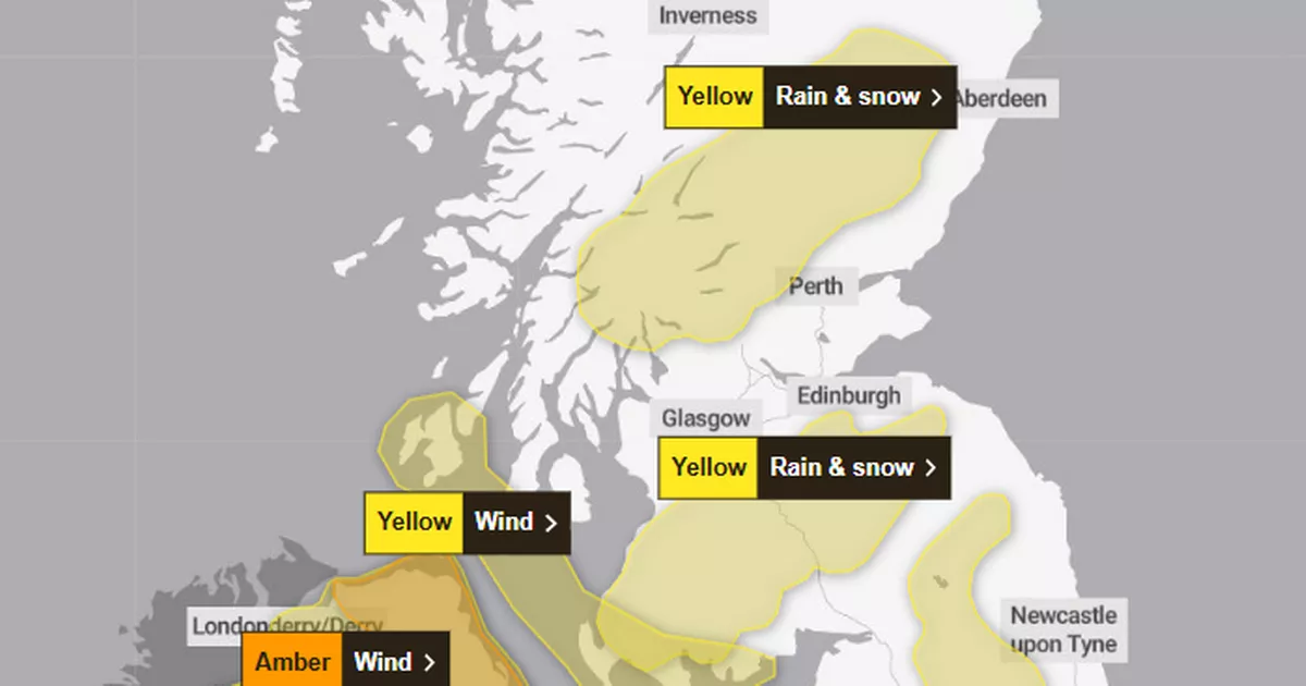
While Scotland has narrowly escaped a more serious amber alert, we haven’t dodged Storm Chandra’s grasp. The sixth named storm of the season is set to bring heavy rain, wind and snow to 16 areas in Scotland – and anyone within these remits should be prepared.
In addition to warnings of 60mph gusts up to 50mm of rain and up to 20cm of the white stuff early on Tuesday, January 27, the national forecaster also foresees flooding and power cuts thanks to incoming weather chaos.
Met Office Chief Forecaster, Paul Gundersen, said: “Storm Chandra will bring a range of hazards to the UK through Monday night and Tuesday. Initially strong winds will impact the Isles of Scilly, western Cornwall and southwest Wales which are still vulnerable after Storm Goretti, gusts of 70 to 80mph are possible here. Heavy rain is an additional hazard as it falls on saturated ground in Dorset and southern parts of Devon, Somerset and Cornwall.
“As Chandra interacts with colder air further north snow becomes a hazard, with 10-20cm of snow possibly accumulating over higher ground in the Pennines, southern Scotland and the Highlands. With a complex spell of weather, its important people stay up to date with the forecast and any warnings in your area.”
As such, households within warning areas are being urged to prepare an emergency kit, for both at home as well as behind the wheel.
While it’s always best to avoid driving in extreme weather, those who choose to should consider packing the following before their journey:
- warm clothing
- food
- water
- a blanket
- a torch
- ice scraper/de icer
- a warning triangle
- high visibility vest
- in-car phone charger
For anyone at risk of facing power outages, gathering the following in advance could be extremely useful:
- torches
- batteries
- a mobile phone power pack
In addition, the Royal Society for the Prevention of Accidents (RoSPA) is urging people to take immediate safety precautions ahead of the arrival of Storm Chandra.
The organisation has issued its own safety advice to the public to reduce the risk of injury and disruption. In addition to avoiding unnecessary travel where flooding is likely, it advises residents to:
- Keep mobile phones and essential devices fully charged in case of power cuts.
- Monitor official weather updates and follow instructions from local authorities.
- Secure outdoor items such as bins, signage and garden furniture to prevent damage or injury.
- Stay indoors during periods of severe weather and ensure windows and doors are securely shut.
- Check in on vulnerable neighbours, particularly those living alone or in rural areas.
The news comes after Scots forecaster Sean Batty recently reported the chances of another cold snap heading to Scotland before the end of the month.
In his insight, which he shared last week, January 22, he stipulated that the the return of subzero temperatures “looks increasingly likely”.
The early January freeze initially came from the north but the upcoming weather front is due to come from the east, “which can often be even colder,” says Sean.
He added: “It’s still too early to pin down the finer details of this potential cold spell, but it’s sensible to be prepared for a return to wintry conditions.”
He suggested this could be the worst winter Scotland has experienced for several years, given how prolonged the spell of below-average temperatures has been.
And he highlighted the potential of the mercury dropping to bone-chilling levels for our biggest city, with places like Scotland risking hitting -8C.


