
News Beat
Storm Chandra: When, Where, And How Bad Will It Hit The UK?
Weeks after Storm Goretti battered the UK coast, Storm Chandra is on its way to our shores.
The area of low pressure is expected to bring strong winds and heavy rain starting Monday night (26 January).
The Met Office has announced some amber and yellow alerts, too, in parts of the UK.
When will Storm Chandra hit the UK?
It’ll reach us today (Monday, 26 January) and is expected to stay until Tuesday (27 January).
Different weather warnings are in place at different times across the UK as the storm makes its way up from the south-west.
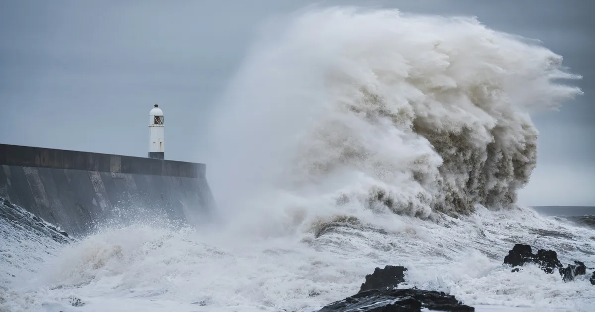
An amber warning for heavy rain is in place in the south-west of England from 5pm, Monday, 26 January.
An amber wind warning for Northern Ireland is in place for eastern parts of Northern Ireland from 5am Tuesday, 27 January, to 9pm that same day.
There are also multiple yellow weather warnings, which are deemed less severe, in other parts of the UK.
This includes a warning for heavy rain in south-west England, Wales and parts of central southern England from 1pm Monday until 10am Tuesday.
Where will Storm Chandra hit the UK?
“Gusty winds will impact the Isles of Scilly, western Cornwall and southwest Wales before moving north up the Irish Sea where eastern parts of Northern Ireland will see impactful easterly winds through Tuesday,” the Met Office explained.
Amber rain warnings are in place for south Devon, much of Dorset, southern Somerset and southeast Cornwall.
Northern England and Scotland have been given a yellow snow warning, as the rain is expected to meet chillier air.
Forecasters predict 10-20cm of snow could fall in parts of the Pennines.
Follow your local forecast closely for the most up to date information.
How bad is Storm Chandra expected to be?
Per Met Office Chief Forecaster, Paul Gundersen, the storm will bring a “range of hazards” to the UK on Monday and Tuesday.
“Initially strong winds will impact the Isles of Scilly, western Cornwall and southwest Wales which are still vulnerable after Storm Goretti, gusts of 70 to 80mph are possible here. Heavy rain is an additional hazard as it falls on saturated ground in Dorset and southern parts of Devon, Somerset and Cornwall,” he explained.
“As Chandra interacts with colder air further north snow becomes a hazard, with 10-20cm of snow possibly accumulating over higher ground in the Pennines, southern Scotland and the Highlands.”
Because Storm Chandra follows storms Goretti and Ingrid, experts think the risk of flooding could be higher in parts of the country.
Up to 60-80mm of rain could fall in south Dartmoor, for instance.
That is why it’s so important to keep up to date with forecasts in your area.
Which weather warnings are in place for Storm Chandra?
As of the time of writing (2:10 PM, 26 January), there are 10 weather warnings in place across the UK for Monday and Tuesday.
These include two amber alerts. One is an amber rain alert for south-east England, starting on 5pm, 26 January and ending 9am 27 January.
Another is for wind in Northern Ireland. It begins at 5am, Tuesday, 27 Jan and ends 9pm that same day.
All of the other alerts are yellow warnings. They include rain warnings in Northern Ireland, England, and Wales, and snow warnings in the Midlands, the north of England, and Scotland.
What does a yellow and amber weather warning mean?
All weather warnings are calculated using a matrix that measures risk and probability.
Yellow weather warnings are the lowest level of weather warning.
Some are given “when it is likely that the weather will cause some low-level impacts, including some disruption to travel in a few places,” though most people are expected to be able to stick to their routines.
Others could be issued when impacts could be worse, but are far less likely to happen.
Amber weather warnings mean a higher likelihood that plans will be disrupted.
“This means there is the possibility of travel delays, road and rail closures, power cuts and the potential risk to life and property. You should think about changing your plans and taking action to protect yourself and your property,” the Met Office explained.
The amber rain warning has a medium likelihood and a medium impact as of the time of writing.
The amber wind warning also has a medium likelihood and a medium impact.
How can I stay safe in Storm Chandra?
Don’t drive, walk, or swim through flood water, the Met Office said. Avoid it if possible, and if you are affected by deep or fast flowing water, call 999 and then wait for help.
Consider preparing a flood kit too incase your house is hit. This could include insurance documents and a list of contact numbers, a torch with spare batteries, a first aid kit and any prescription medicines, warm waterproof clothing and blankets, bottled water and snacks, a battery-powered or wind-up radio, and supplies for looking after a baby or pet.
Chris Wilding, the Flood Duty Manager at the Environment Agency, stressed that driving in flood water is really unsafe.
“We urge people not to drive through flood water – it is often deeper than it looks and just 30cm of flowing water is enough to float your car,” he said.
“People should search ‘check my flood risk’, get free flood warnings, and keep up to date with the latest situation at @EnvAgency on X.”


