
News Beat
Strong winds of up to 65mph expected across UK as yellow weather warnings issued

The Met Office has issued yellow weather warnings throughout the week as heavy rain, brisk wind and snow are forecast across the UK.
The wintry conditions will be most notable throughout the southwest of Britain, as several areas in the region, along with Wales, come under a 12-hour yellow warning from 4am on Tuesday.
A 48-hour weather warning will then come into force for areas in Central, Tayside and Fife, Grampian, and Highlands and Eilean Siar from midday on Wednesday, as the forecaster predicts persistent, heavy rain and possible flooding.
Met Office chief forecaster Paul Gundersen said: “A spell of strong winds and heavy rain is expected to affect southwest England and parts of Wales during Tuesday. Inland winds gusts could reach 45 to 55mph, and possibly 60 to 65mph over the most exposed hills and coasts.
“Heavy rain accompanies these winds and could bring some disruption to vulnerable places such as Cornwall, which is still feeling the effects of Storm Goretti.”
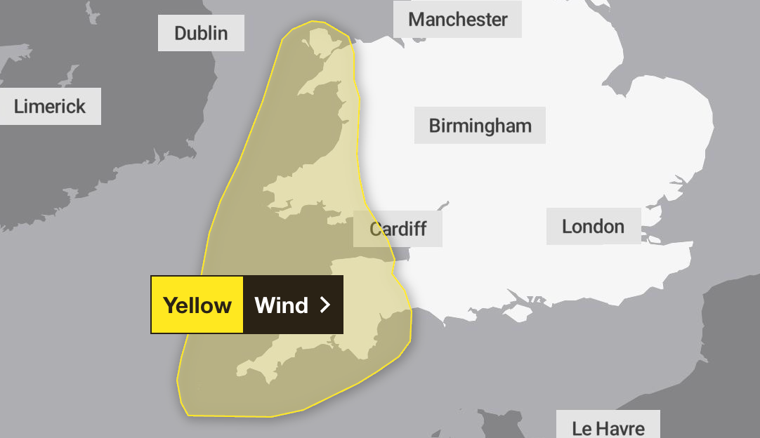
From Wednesday, brisk winds and bands of rain will head north, as areas in Scotland come under a weather warning. Rainfall of 30 to 60mm is expected across the region, with up to 80 to120mm possible over high ground.
The Met Office warned there is a small chance of homes and businesses being flooded, as well as power cuts and road closures.
Met Office deputy chief forecaster Dan Holley said: “Given the nature of the ground following recent rain and snow thaw, this may lead to some flooding in places. Rainfall totals will be smaller in coastal areas, but strong onshore winds and large waves at times will be additional hazards.
“Rain will also turn increasingly to snow on high ground through Thursday and Friday, which complicates the picture as to how quickly rivers may respond downstream.”
The Met Office said the weather was still expected to get colder next week as competing weather systems attempt to push in wet weather from the West and colder and drier conditions from the East.

Met Office five-day weather forecast
Monday
A rather grey day with some fog remaining stubborn to clear and plenty of low cloud. Outbreaks of rain also continuing in central areas, with the brightest skies across northern Scotland. Temperature close to, or slightly above average.
Overnight
Remaining cloudy with rain moving northwards, locally heavy in Northern Ireland. Some clear spells in between cloud will allow frost to develop in the North and West. Turing windy in the South West.
Tuesday
Cloud breaking across central and northern areas, but remains around western and eastern coasts. Rain in the West, can be heavy in the South West where winds will strengthen. Average temperatures.
Outlook for Wednesday to Friday
A changeable few days, often cloudy with some brighter spells but also outbreaks of rain. Turning windier in the north later in the week. Could turn colder here.


