Connect with us
DAPA Banner
DAPA Coin
DAPA
COIN PAYMENT ASSET
PRIVACY · BLOCKDAG · HOMOMORPHIC ENCRYPTION · RUST
ElGamal Encrypted MINE DAPA
🚫 GENESIS SOLD OUT
DAPAPAY COMING

NewsBeat

an ancient Amazonian world revealed from the sky

Published

on

an ancient Amazonian world revealed from the sky

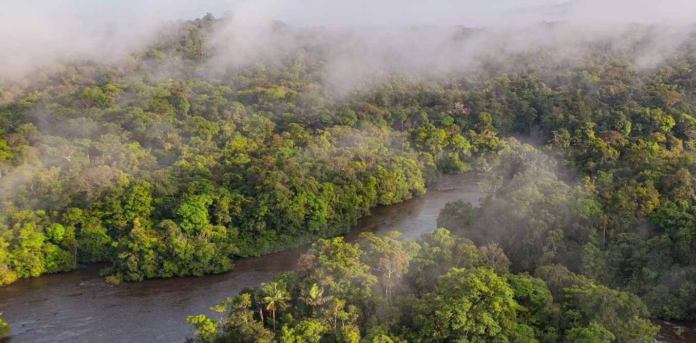
From the air, you see it only through the constant jolt, tilt and shudder of the low-flying Cessna aircraft. The landscape of the Llanos de Moxos, northern Bolivia, appears as a disconnected patchwork of open grassland savannahs, forest islands and lakes.

It feels random, almost unreadable. Only gradually does the pattern resolve itself: raised causeways or paths fanning out to link the forest islands, and a dense, scattered web of canals threading the terrain. Slowly you realise it’s a structured network of intersecting lines, enclosures and roads – the imprint of past human design.

Aerial view of Llanos de Moxos.
Jose Iriarte, CC BY-SA

If you stand on the open savannah, there is almost nothing to see of this ancient network. The horizon feels open, with fires in the distance from local people burning pastures and clearing forest as dry season begins. The old geometry is still faintly perceptible, but you have to know how to look.

Advertisement

Step into the patches of forest and the canopy closes in. The earth softens underfoot and mosquitoes descend in relentless swarms. The sweat on your neck thickens into a humid film, carrying the familiar scent of suncream and the sharper, chemical note of DEET.

In the uneven light between the trees, the landscape dissolves into subtle rises and depressions. Against the rhythmic swish of machetes as our guides cut through the vegetation, your mind tries to piece together the fragments of structures into something coherent. Flying overhead doesn’t reveal anything about this forest area in the way that it does with the savannah. But fortunately recent advances in technology have transformed what we are able to see.

Surveying in the Amazon rainforest

Surveying in the dense Amazon rainforest.
Jose Iriarte, CC BY-SA

Archaeological explorations in this part of the world have been completely changed by lidar in the past couple of decades. Lidar maps an area from a plane or drone by bouncing rapid laser pulses off the Earth’s surface. Some of these pulses penetrate the forest canopy, reach the ground and reflect back to the sensor.

By measuring the return time, the system can generate highly precise three-dimensional models of the terrain. This allows you to strip away the camouflage of vegetation, making it possible to see what lies below the Amazonian forest for the first time.

Advertisement

It reveals the ancient Llanos de Moxos as not simply a collection of settlements, but an entire urbanised landscape. A large part in the south-east of this region belonged to the Casarabe culture, which dominated between around AD500 and 1400. It extends across 20,000km², which is roughly the size of New Jersey in the US.

The Casarabe organised into a hierarchy of four different sizes of settlements (those forest islands mentioned above). The biggest ones – the primary settlements – were as large as 3km² or 300 hectares. That’s enough space for over 400 football pitches, suggesting that they could have accommodated substantial numbers of people.


Welcome to our series on the great mysteries of archaeology. Viking explorers, Amazonian cities, artefacts from before civilisation. Archaeology may be all about the past, but it’s constantly shifting with every scientific discovery. This series will dig into some of the most fascinating debates in the field today.

Advertisement

These settlements connect along the raised causeways to smaller secondary and tertiary sites a number of kilometres away, all of which were permanently inhabited as opposed to empty ceremonial hubs. A fourth tier consists of groups of isolated mounds located out in the pampas, which likely correspond to dwelling areas occupied by farmers who would have worked the fields.

It’s not possible to show a lidar image of these four different types of sites interconnecting because they are too far apart for the resolution available, but the image below of a primary settlement known as Loma Cotoca shows the kinds of things we are now documenting.

Aerial shot of Loma Cotoca

Lidar shot of Loma Cotoca.
Jose Iriarte, CC BY-SA

It features some very impressive civic-ceremonial architecture: conical pyramids over 20 metres tall and U-shaped structures that may have acted as areas for public gatherings for speeches or ceremonies. These were built on top of man-made platforms rising as much as five metres off the ground and extending over 20 hectares. To be clear, this is all still hiding under the forest, but the lidar data reveals the shape, height and layout of what lies below.

The volume of earth moved to create this architecture would have rivalled – and in some cases exceeded – that of well known Andean monuments such as Akapana a few hundred miles to the south-west on the other side of the Andes. Akapana was the epicentre of the Tiwanaku empire that dominated the southern Andes between about AD600 and 1000.

Advertisement
Akapana pyramid in Tiahuanaco o Tiwanaku.

Akapana pyramid in Tiahuanaco o Tiwanaku, Bolivia.
Wikimedia, CC BY-SA

Yet where monuments like Akapana were surrounded by classic, compact bounded cities with thousands of inhabitants, the Casarabe equivalent was completely different. This was dispersed, low-density living amid extensive green space – a form of tropical urbanism that challenges longstanding assumptions about this area as sparsely populated and only lightly modified. It invites comparison with other low-density tropical urban landscapes such as the Maya in central America and the Angkor in latter day Cambodia.

Equally important is the coherence of the Casarabe system. The settlements are rarely isolated, part of a tightly connected network with shared water-management systems. It was clearly all planned and coordinated, designed not only as living spaces but for integrating the population across the region.

We can see that the Casarabe were sustained by drained-field agriculture: the canals were dug to make the land viable for planting during the wet season. The most prominent crop was maize, but there was a remarkable diversity of other produce. This was all embedded within a landscape that was engineered through reservoirs and farm ponds, which helped the Casarabe sustain cultivation and maintain access to water through the dry season in this extremely seasonal environment.

Also very noticeable is the fact that all the major architectural features and burial sites are oriented north-north-west. This suggests these people may have been led by cosmology, with important celestial bodies or regions of the night sky serving as symbolic reference points – hinting at a world where infrastructure, settlement and belief were inseparable.

Advertisement

Rethinking the Amazon

The Casarabe culture covered much less than 1% of Amazonia, which is the whole tropical interior of South America, spanning close to half of the entire continent. For much of the 20th century, this vast area was viewed by archaeologists as an environment that was limiting for human existence.

Poor soils, scarce game, extreme El Niño floods and droughts, and the challenges of tropical disease were all thought to constrain human populations to small, wandering groups living off the land as best they could. Large, settled societies – let alone towns or cities – were considered unlikely, if not impossible.

This view began to shift in the late 20th century for several reasons. Archaeologists realised that Amazonian people had been domesticating a diversity of plants since the end of the Ice Age. They manufactured some of the earliest ceramics in the Americas, and also devised soils known as Amazonian Dark Earths, which combined charcoal, bone and waste materials with the existing poor-quality soil to make it fertile enough for widespread farming.

Advertisement
Indigenous planting in Peru

Specially engineered Amazonian soils unlocked widespread farming.
Carlos Mora

It also became apparent that just like the Casarabe people, many other cultures across Amazonia had reclaimed vast expanses of seasonally flooded savannahs over several thousand years to create raised and drained field systems.

These discoveries were evidence of long-term settlement and landscape management far beyond what was previously thought possible. It meant Amazonia was not simply a backdrop to human activity; much of the landscape was shaped over the last 13 millennia by the people who lived there.

Enter lidar

Like lasers in the sky, lidar technology has accelerated this transformation in our understanding. The digital process feels near-magical, a “vegetation removal algorithm” that reveals the secrets below.

In practice, however, working with lidar in Amazonia is anything but straightforward. Running such a project here, as I have done, can feel like one of the greatest emotional rollercoasters in field archaeology. It’s all anticipation, frustration and sudden revelation – only comparable, perhaps, with shipwreck exploration.

Depending on what technology is available and most suitable for exploring a particular area, I’ve worked with lidar attached to drones, aeroplanes and helicopters. I’ve learned through trial and error that the technology is only as effective as the logistics and personalities behind it – above all on one occasion when we were trying to integrate a Hungarian lidar sensor with a Brazilian drone.

Advertisement
Shot of a drone and big smiles as it finally worked

Above: the ‘Experimental’ drone; below: the moment it finally worked – the smiles in the control station say it all.
Jose Iriarte, CC BY-SA

Lidar can perform beautifully one day and fail the next, depending on the equipment, weather, terrain, batteries, communications and the sheer difficulty of operating in remote Amazonian conditions.

Flights must be carefully planned in remote areas with limited infrastructure, where convective clouds, smoke from fires, wind and even vultures riding thermals can disrupt data acquisition. You have to arrange fuel in advance and improvise landings wherever a safe clearing can be found. Here’s our team refuelling a lidar helicopter in the football field of a small village in Acre state, western Brazil:

You also have to do constant troubleshooting with the technology, such as making sure it’s calibrated correctly and that the data from different flight paths all aligns. What appears in the final images as a seamless “removal” of the forest is, in reality, the product of improvisation, negotiation and persistence.

Advertisement
Percy Fawcett photograph

Percy Fawcett.
Wikimedia, CC BY-SA

But given all these challenges, it makes the first successful images all the more powerful when they finally appear. The reward is that we’re finally finding the “lost civilisation” that explorers like Percy Fawcett were searching for a century ago, but by cajoling a drone rather than battering through jungle.

Incidentally, this technology also has important uses beyond archaeology. It can help people to locate and harvest crops like rubber or açaí palm fruits without having to clear so much rainforest. It is also used by pioneering projects such as Amazonia Revelada, which helps Indigenous and traditional people of the Amazon to prove their historic presence within an area to ward off modern commercial interests like loggers or farmers, while also protecting the living history and nature embedded in these landscapes.

Other lidar discoveries

Lidar surveys by French and Ecuadorian archaeologists have revealed that the Llanos de Moxos was certainly not the only example of large-scale, highly integrated society in Amazonia. The Upano Valley, which covers some 300-600km² on the mountainous forest of the Ecuadorian eastern flanks of the Andes, offers another striking example – this time from between about 500BC and AD600–700.

Lidar discovery areas

Advertisement
Map of South America showing settlements traced by lidar


Felt, CC BY-SA

In Upano, archaeologists have been able to map a vast network of settlements connected by extensive road systems, with large platforms and clusters of buildings arranged in organised layouts across a broad area.

What stands out is not just the scale – thousands of structures – but the rigour of the planning. The settlements didn’t just grow randomly, but as part of a deliberate design: we see straight lines of flat-topped platforms laid out in repeating rows and connected by straight paths that cut cleanly across the landscape, as you can see below.

Lidar footage of settlements in the Upano Valley.

Lidar footage of settlements in the Upano Valley.
Jose Iriarte, CC BY-SA

Again, this is not urbanism in the conventional sense of dense, continuous occupation. There would have been none of the vertical stacking of buildings that you’d get in European settlements, and there were also green spaces between platform complexes – much more like a forest city.

Like the Casarabe region, this is a distributed settlement pattern that is both open and highly structured, but the arrangement is much more compact. This reflects the limited flat space available on the upper terraces of the Upano River, which rise up to 100 metres above the surrounding landscape.

Advertisement

Elsewhere in Amazonia, we see more variations. In the Upper Xingu of central Brazil, interconnected settlements were arranged around a shared ceremonial and road network, again suggesting a regionally coordinated social world.

Further north, the Tairona people of the Sierra Nevada de Santa Marta in present-day Colombia built terraced stone towns in the mountains, linked by paved paths. This was a form of urbanism shaped entirely by the demands of steep, high-altitude terrain. Below is a lidar image of one area in this region, with the platforms that would have housed the settlements marked in yellow. Below that, you can see what the platforms look like.

Above: lidar image of settlements at Teyuna-Ciudad Perdida in yellow; below: an actual shot of the platforms that housed the settlements.

Above: lidar image of settlements at Teyuna-Ciudad Perdida in yellow; below: an actual shot of the platforms that housed the settlements.
Daniel Osorio, CC BY-SA

In western Amazonia, Acre adds another important variation. From around AD1–1000, people built large ditched enclosures, or geoglyphs, mainly in the south-eastern part of this region along the upper Purus River. These were square, circular, hexagonal or octagonal mounds, often 1-3 hectares in size, with ditches up to four metres deep. These were probably used as ceremonial gathering places rather than permanent settlements.

After about AD1000, these were followed by what we call circular mound villages, occupied until around AD 1650–1700. They featured rings of mounds around central plazas and straight roads radiating out like the rays of the Sun, often built to align with the four main compass points. These “Sun villages” were true settlements, and formed interconnected networks across the southern rim of Amazonia. You can see an example in the lidar image below.

Advertisement
Circular mound village lidar image at Acre, Brazil.

Lidar image of circular mound village Dona Maria at Acre, Brazil.
Jose Iriarte, CC BY-SA

Taken together, these discoveries fundamentally reshape our understanding of Amazonia. We now see a mosaic of managed landscapes, engineered environments and, in some cases, city-scale societies. What unites them is not a shared blueprint but a shared impulse: the organisation of people, space and movement across large landscapes in ways that were deliberate, durable and distinctly their own.

To stress, Amazonia was not uniformly dense or urban. It supported a diversity of types of settlements, from dispersed networks like Moxos to tighter grids like Upano, each of them adapted to local ecological conditions. They shared a low-density urbanism, in the sense of large, interconnected populations without the density of classic cities.

What we still don’t know

How were these societies organised politically and socially? How did they interact with variations in the climate and environment, ranging from the heavy rainfalls and droughts caused by El Niño to rivers forging new routes that could move them away from a settlement within a few generations?

What, if any, connections existed with mountain societies in the Andes? And perhaps most importantly, since both the Casarabe and Upano ceased to build monuments after 1492, what led to their transformation or decline before the arrival of Europeans?

Advertisement

There is active debate between archaeologists over whether these societies transformed because of environmental stress, internal political change, or shifts in things like trade routes or migration.

In the Llanos de Moxos, one possibility is that a prolonged period of climate change affected the Casarabe water-management systems that were so critical to feeding this thriving society. In the Upano Valley, volcanic eruptions and earthquakes may have disrupted settlements and agriculture, although it’s unclear whether that could have led to the area being abandoned.

It seems likely that as we uncover new things, it will reveal more and more integration between different societies. What we are seeing now in Amazonia is much like looking at a satellite image of a country at night: bright, isolated clusters of light – cities that appear disconnected. But as we continue to expand our coverage and fill in the gaps, I think this will change.

What now appear as isolated clusters may also resolve into extensive networks. For example a study across the southern rim of Amazonia has predicted that the kinds of settlement mounds that have been identified so far are likely to occur across about 400,000km², supporting an estimated regional population of roughly 500,000 to 1 million people in the era before the Europeans arrived.

Advertisement

Entire regions may emerge as previously unrecognised centres of population and landscape management. This could be particularly so for the Llanos de Moxos. The whole area covers as much as 200,000km², depending on where you draw the boundaries, stretching into Brazil and even Peru. It is often divided into several apparently distinct cultural regions — the Casarabe (aka the monumental mound region), and then two others called the platform ridge and zanjas (ditches) regions.

As lidar coverage expands and more archaeological work is conducted, we may begin to understand how these societies were economically specialised. We know, for example, that the fortified villages of the zanjas region had fish weirs spanning hundreds of miles that were capable of capturing vast quantities of migratory fish. The platform ridge region consisted of large drained fields, which could potentially produce surpluses of maize. It is conceivable that these belonged to a broader network that supported the more complex Casarabe centres.

Or perhaps – who knows – the relationships were more fluid and reciprocal. For now, the question remains open. But it is precisely this possibility of deep regional integration that lidar is beginning to bring into view. In time, we may even begin to identify Casarabe outposts scattered across the Llanos de Moxos.

What happens next

There’s still a huge amount to be done with lidar. Vast areas, particularly in the Ecuadorian and Peruvian Amazon – remain unexplored. One recent study suggested that there could be more than 10,000 more urban structures of the kind I’ve been describing still hidden throughout Amazonia, all of them dating from pre-European times.

Advertisement

Looking ahead 20 years, it is likely that our map of Amazonia will look very different. One promising technology is satellite-based lidar systems, which could provide broader, though less detailed, datasets across large areas. Advances in machine learning are also beginning to help us identify archaeological features within massive datasets, speeding up a labour-intensive process.

Against this, there are time pressures in some places. Llanos de Moxos, for instance, is unfortunately in rapid transition. The very ground that holds the traces of ancient networks is being transformed by mechanised agriculture and large-scale terraforming for rice cultivation and pastures.

We also need to keep reminding ourselves that lidar is only the first step. What really matters is how it’s brought together with other lines of evidence. Most sites discovered by lidar have yet to be excavated, so we’ll have to do much of that, looking for everything from bones and plants to ceramics and weapons.

So far, most excavation has been in the Casarabe area of the Llanos de Moxos. The reason, for instance, that we know the culture lived primarily on maize was through the discovery of over 60 human skeletons, which underwent carbon isotope analysis. The same research paper also analysed excavated duck bones to show that the Casarabe were feeding them maize too, suggesting animal domestication in a continent that was not generally known for it.

Advertisement

Another fascinating Casarabe find is a single buried skeleton who may have been a leader, because he had a collar of jaguar teeth around his neck. He was also wearing ear pieces made of armadillo shell, studded with mottled blue stones called sodalite – it’s not clear what these were for.

Male skeleton in Loma Salvatierra

Male burial in Loma Salvatierra, Llanos de Moxos, shows: a) plate of cooper; b) earpieces with pearls of sodalite and armadillo shell; c) a collar of jaguar teeth; d) shell beads; e) bracelet of shell.
Heiko Prümers/Jose Iriarte, CC BY-SA

We’ll also need to obtain more precise dates for key events using techniques like radiocarbon dating, and more pinpoint accurate environmental data to help support theories about ancient changes to the climate – as opposed to the wider regional information we’ve tended to rely on until now. Lake sediments are great environmental archives, preserving evidence of things like vegetation change and landscape disturbance.

Also important is comparing genetic data from excavated bones with people who live in these areas today – in dialogue and collaboration with local communities whose histories, memories and knowledge are essential to understanding these landscapes.

It’s all a question of how lidar is brought together with all this other evidence. The most convincing reconstructions will come from the convergence of all of these. One further major challenge ahead, however, will be to bridge the gap between scientific reconstructions and how past peoples understood and inhabited their world. Archaeology is increasingly rich in data, but we have to relate it to lived experience.

Advertisement

That is no easy feat, but it is essential if we are to move from mapping past worlds to understanding them. Crucially, Amazonia – with its rich, still-vibrant Indigenous societies and ethnographic record – offers an exceptional opportunity to do this, providing rare continuities through which to anchor and critically engage our interpretations of the past.

Lessons for today

My own sense is that we will move towards a view of Amazonia not as an exception, in line with the old view that the people lived within an untouched paradise, but as part of a broader pattern of human-environment interaction. The rainforest will be understood not only as a biological system, but as a historical one – shaped, in part, by the people who lived within it.

This does not mean the Amazonian people who simply lived “in harmony” with nature; the evidence points to something more interesting. Although Amazonian societies developed complex, and at times intensive, forms of land use, the evidence consistently shows that they often did so while maintaining continuous forest cover. Far from the large-scale deforestation that we might assume was necessary for such elaborate forms of human life, their practices created mosaics of managed forest, gardens, orchards, wetlands and settlement areas.

We know partly from lake sediment data that people enriched the forests with species that provided food, building materials, medicines and other resources, from açaí and cacao to palms, cinchona and copaiba. The fact that some of these species endure today suggests that past land use left lasting ecological legacies.

Advertisement
Acai palm

Amazonian açaí is one of numerous species that are not prevalent by accident.
Guentermanaus

In the context of today’s climate crisis, the long-term balance that these people achieved offers a powerful lesson: it is possible to sustain complex societies without destroying the forest, if land use is guided by principles that integrate ecological knowledge, cultural values and a commitment to the continuity of the living landscape.

What lies beneath the Amazon is not just a hidden past. It is a reminder that even the most seemingly untouched landscapes can carry deep histories, waiting – sometimes just beneath our feet – to be revealed.

This article features references to books that have been included for editorial reasons, and may contain links to bookshop.org. If you click on one of the links and go on to buy something from bookshop.org The Conversation UK may earn a commission.


For you: more from our Insights series:

Advertisement

To hear about new Insights articles, join the hundreds of thousands of people who value The Conversation’s evidence-based news. Subscribe to our newsletter.

Source link

Advertisement
Continue Reading
Click to comment

You must be logged in to post a comment Login

Leave a Reply

NewsBeat

Andy Burnham is running in a UK election that could make him Britain’s next leader

Published

on

Andy Burnham is running in a UK election that could make him Britain's next leader

ASHTON-IN-MAKERFIELD, England (AP) — About 75,000 voters in a pocket of northwest England are about to make a momentous decision. They will cast ballots in a contest that may well pick the U.K.’s next prime minister, or plunge Britain’s febrile politics into even more turmoil. Possibly both.

Some of them aren’t too enthusiastic.

“I think they’re all a waste of time,” said Shirley Prior on the choice of candidates in Makerfield, where a special election on June 18 has drawn interest from journalists around the world. That level of attention is all-but unheard of for a midterm by-election to fill one of the 650 seats in the House of Commons.

If Andy Burnham from the center-left Labour Party wins, there’s a strong chance he will replace embattled Prime Minister Keir Starmer as leader of both party and country. He’s up against Reform UK, a hard-right party hoping to prove that this longtime Labour stronghold is fertile ground for its anti-immigration message, with potentially seismic consequences for British democracy.

Advertisement

This district has elected Labour lawmakers for 120 years, but Burnham is not a shoo-in. Reform, led by the veteran anti-immigration politician Nigel Farage, won 24 of the 25 council seats up for grabs in local elections in this area last month.

“I always voted Labour because my dad, my grandad, everybody voted Labour then,” Prior said. “I’ve never done that for a lot, a lot of years.”

Immigration is a top issue

The election is taking place amid heightened tensions over immigration. A stabbing in Belfast this week, for which a Sudanese man has been charged with attempted murder, triggered violent protests in Northern Ireland in which cars and houses torched.

In the constituency’s main town of Ashton-in-Makerfield, 200 miles (320 kilometers) northwest of London, some voters echo Reform claims that recent arrivals are straining housing and public services.

Advertisement

“Immigration’s too high, all the services are being put under pressure and Labour just keep inviting more and more people into the country and it’s the taxpayer who has to pay for them,” said retiree Phil Arrowsmith.

Annual net migration to the U.K. reached more than 900,000 in 2023, under the previous Conservative government, before falling to 171,000 last year.

That decline has done little to boost a Labour government that has floundered since winning election in July 2024.

Starmer has struggled to deliver promised economic growth, repair tattered public services and ease the cost of living, and been hamstrung by repeated missteps, including his decision to appoint Peter Mandelson, a scandal-tarnished friend of Jeffrey Epstein, as Britain’s ambassador to Washington.

A dismal performance in local elections last month sparked a clamor from Labour lawmakers for Starmer’s resignation. He has refused, but Cabinet minister Wes Streeting quit so he can run in a leadership contest that could come soon.

Burnham, the popular mayor of Greater Manchester, also harbors leadership ambitions, but needs a seat in Parliament if he wants to challenge Starmer. An opening emerged when Josh Simons, the Labour lawmaker for Makerfield, stepped down to trigger a special election.

Advertisement

Burnham said he understands that voters are “fed up” and calls the large Reform UK vote “a cry for real change” that Labour must heed.

The ‘King of the North’ eyes power in London

The Makerfield constituency is a capsule of British history, a collection of former coal-mining communities turned commuter suburbs. The slag heaps and slum housing in the area described by George Orwell in his 1937 book “The Road to Wigan Pier” have been replaced by suburbs of tidy modern houses amid Victorian workers’ cottages, interspersed with farmers’ fields.

Though far from the city center, it is part of Greater Manchester, and Burnham gets honks and thumbs’ ups from passing drivers as he walks down the street in his smart-casual uniform of dark jeans with a navy blue shirt and jacket.

The 56-year-old has been mayor of the region of 3 million people since 2017, a period that has seen central Manchester boom, with skyscrapers blooming on postindustrial sites. Many residents praise him for championing the city, and for taking a piecemeal public transport system under municipal control as the Bee Network.

Advertisement

For a decade and a half before that he was a lawmaker in Parliament, and a minister in Labour governments. He doesn’t emphasize that part of his CV, preferring the outsider status that has seen him nicknamed the King of the North.

“What we’ve built in Greater Manchester needs to go national,” Burnham told reporters during a campaign event this week. “I know what it is to turn places around.”

Many predict a close contest

The campaign is an odd mix of the local and the international. Some voters cite immigration as a top concern. Others mention struggling main street shops, potholes and petty crime.

Burnham’s main rival is Reform UK candidate Rob Kenyon, a 41-year-old plumber and local councilor who came second to Labour here in the 2024 national election. He says he’s an unpolished regular bloke, though opponents have criticized him over crude, sexist and anti-vaccine comments on social media.

Advertisement

Reform voters are also being targeted by Restore, an even more hardline anti-immigration party.

Michael Poultney, a retired teacher and Labour supporter, thinks the unpopularity of Starmer’s government means Burnham faces a stiff challenge.

“Without his personal vote, I think we would struggle,” he said. “Keir Starmer has done reasonably well on the international stage, but the government are yet to be in control of the economy.”

Burnham insists he is running for the people of Makerfield, not his own ambition, and is not taking victory for granted.

Advertisement

“I am making no assumptions beyond the 18th of June,” Burnham said.

But he stressed that “this is a change byelection.”

“I will take the fight for the changes I want to see in politics as far as I can take it,” he said.

Advertisement

Source link

Continue Reading

NewsBeat

Phone thefts halve in central London as Apple joins police crackdown to make stolen handsets ‘unusuable bricks’

Published

on

Phone thefts halve in central London as Apple joins police crackdown to make stolen handsets 'unusuable bricks'

“If we share the data we have on the phone stolen, with the data they have on things like reactivations and future uses of phones, we can get a global picture of phones being stolen, are they being reactivated, are they being broken down for parts, where they’re being exported to in the world,” he said.

Source link

Continue Reading

NewsBeat

Tzatziki dip will come out tastier and even richer if you do one simple task before making it

Published

on

Daily Mirror

A homemade tzatziki sauce is perfect for a summer barbecue or picnic, but it can often turn out watery if you do not do a simple two minute task before making it.

June marks the official start of summer in the UK, and as we enjoy abundant sunshine, nobody fancies spending hours confined indoors preparing dinner. Greek food is ideal for this season as it’s light, flavoursome and typically remarkably swift to whip up, with tzatziki being among the easiest recipes to create.

Advertisement

Tzatziki is a creamy garlic dip frequently served alongside grilled meats at a barbecue or tucked into wraps for a picnic, though it’s equally moreish on its own with warm bread or crisps. It often delivers better results when homemade, as it requires just a few minutes to prepare and calls for basic ingredients that most people already have in their cupboards.

However, Jeanine Donofrio, a cook and founder of Love and Lemons, has revealed that while tzatziki is straightforward to make, it’s crucial to use a tea towel if you want it to be as creamy and thick as possible.

Jeanine explained: “Squeeze the water out of the grated cucumber. This step is essential for making a creamy tzatziki – if you skip it, the water from the cucumber will cause your sauce to separate. Squeeze the cucumber directly over the sink, or press it lightly between kitchen or paper towels.”

Advertisement

Cucumber is vital in tzatziki because it provides the dip with its fresh flavour, but it holds a considerable amount of water and adding it directly to the bowl can leave the mixture saturated with excess moisture.

This can dilute the tzatziki sauce and render it watery, which means it won’t stick properly to bread, crisps, vegetables or meat.

Failing to get rid of this excess moisture will also cause the dip to carry an overpowering cucumber flavour rather than a satisfying garlicky kick, meaning it simply won’t be as tasty as it ought to be.

Many people just chuck all the ingredients into a bowl, but if you’re after a tzatziki that tastes creamier, richer and more authentic, it’s well worth spending two minutes preparing the cucumber properly.

How to make proper tzatziki sauce.

You will need:

  • 240g of Greek yoghurt
  • Half a cucumber (around 75g)
  • One tablespoon of lemon juice
  • One garlic clove (grated)
  • One tablespoon of chopped dill
  • One tablespoon of mint (optional)
  • Half a tablespoon of extra-virgin olive oil
  • A pinch of sea salt

Method:

Start by grating the cucumber and garlic. Next, place the cucumber in a clean tea towel and gently squeeze out as much excess water as possible.

Then, in a medium bowl, combine the cucumber, garlic, yoghurt, lemon juice, olive oil, salt, dill and mint (if using). Stir everything together until you achieve a smooth, consistent sauce.

Advertisement

You can serve it straight away if you’re in a hurry, but for a superior flavour, cover the bowl and pop it in the fridge for at least 30 minutes.

This allows all the ingredients to meld together, resulting in a much brighter and more garlicky taste, as the sauce tends to develop a better texture once properly chilled.

Tzatziki works brilliantly on its own as a dip alongside crisps, crackers or chopped vegetables. It also pairs wonderfully with Mediterranean salads, sandwiches and even draped over grilled meat for anyone firing up the barbecue this summer.

Advertisement

Source link

Continue Reading

NewsBeat

Transfer news LIVE: Arsenal FC target Williams, Vinicius Jr decision; Anderson bid; Man Utd, Liverpool latest

Published

on

Transfer news LIVE: Arsenal FC learn Kroupi fee; Alvarez bid; Wharton to Man Utd; Chelsea, Liverpool latest

Arsenal, Chelsea, Liverpool and Manchester United have run out of time to get business done before the World Cup begins this evening, though they are all working hard behind the scenes with the summer transfer window fast approaching. The Premier League champions, Arsenal, hold an interest in Morgan Rogers, Eli Junior Kroupi and Sandro Tonali, are in talks for wonderkid Jeremy Monga and have been linked with a stunning swoop for Vinicius Junior as well as Nico Williams.

Source link

Continue Reading

NewsBeat

Savage House’s filth and farce are closer to the real bawdiness of the 18th century

Published

on

Savage House’s filth and farce are closer to the real bawdiness of the 18th century

Although critics have praised the performances in Savage House, the film itself has received a frosty reception.

Tim Robey in the Telegraph described its “putrid stylings” as making it “impossible to enjoy”, dismissing it as a “rancid” and “rotten” period drama. Yet this allegedly “lowbrow” film captures the spirit of 18th-century culture more effectively than many glossy period dramas. Savage House seems outrageous because we have forgotten how outrageous the 18th century could be.

Set during the Jacobite Rising of 1715 and a smallpox outbreak, the film follows Sir Chauncey Savage (Richard E. Grant), a former highwayman whose gambling addiction and taste for luxury have left his Yorkshire estate on the brink of ruin. When the Duke and Duchess of Devonshire announce a visit, the Savages see one final chance to restore their social standing.

What follows is a classic farce, structurally and thematically reminiscent of 18th-century plays like John Gay’s The Beggar’s Opera (1728) or Richard Brinsley Sheridan’s School of Scandal (1777). As the visit approaches, disasters accumulate: disease spreads, affairs threaten exposure, Chauncey’s gout worsens, and panic grows over an impending eclipse. Along the way there is madness, mutilation, vomit, chamber pots and an astonishing amount of human excrement.

Advertisement

Far from being anachronistic, much of this owes a great deal to 18th-century literature and art. However, the modern imagination struggles to see this era as impolite, largely because Jane Austen’s literary vision of Georgian Britain (1714 to 1837) has become so dominant.

Austen’s stories depict a culture shaped by manners and social refinement where sex and dirt are practically non-existent (or buried beneath layers of polite language). Such ideas of the period have more recently been cemented by the Regency-era period drama Bridgerton. How could the early 18th century, then, be so different from Austen’s depictions of the later Georgian period? It can’t, is what many of The Savage’s critics have concluded. However, in reality, earlier 18th-century writers often revelled in something much earthier.

In a poem addressed to the Irish writer and essayist Jonathan Swift, Lady Mary Wortley Montagu joked that Swift’s verses would “furnish paper when I shite”. She was responding to Swift’s notorious satire The Lady’s Dressing Room (1732), in which a servant discovers that the seemingly perfect Celia is, in fact, a human being who uses the toilet. Upon glimpsing the contents of her lavatory, the servant emerges running and shouting “Oh! Celia, Celia, Celia shits!”

Advertisement

Scatology, an interest in bodily waste, runs throughout Swift’s writing, including Gulliver’s Travels (1726). When Gulliver finds himself locked up by the miniature citizens of Lilliput, one of his most urgent concerns is how he is going to discharge his body of its “uneasy load”, since he hasn’t had the opportunity for any toilet time since his ship sunk hours earlier.

Much later in the novel, when he encounters the Yahoos, a species of degenerate humans, he is appalled to discover that they throw excrement at one another. For Swift (who is name checked in Savage House as a potential guest for the Devonshire’s visit) such moments served a satirical purpose. They punctured human vanity by reminding readers that, however refined they imagined themselves to be, they remained creatures of flesh, appetite and bodily functions. Everything else was artifice.

That tension between appearance and reality lies at the heart of Savage House. As literary historian Pat Rogers observed, 18th-century Britain was a “freakish age”, one that celebrated refinement while indulging its basest appetites. Small wonder that bathos (the sudden collapse of the elevated into the ridiculous) became one of the period’s favourite satirical techniques.

William Hogarth A Rake’s Progress, In The Madhouse.
Wikimedia, CC BY

Savage House’s clearest influence is William Hogarth’s A Rake’s Progress (1733 to 1735), a sequence of satirical paintings charting the rise and fall of Thomas Rakewell, a young heir who squanders his fortune on gambling, luxury and vice before ending up in the psychiatric hospital, Bedlam. A “rake” is someone committed to hedonism, whose voracious appetites lead them to live their lives to excess in all matters. Like Rakewell, Chauncey Savage is a classic rake, and the connection becomes explicit in the film’s closing moments, which directly echo Hogarth’s final image.

Advertisement

Unlike Rakewell, however, Chauncey is not born wealthy but cons his way into respectability. In this respect he resembles the ambitious adventurers and social climbers of Henry Fielding’s fiction, especially Tom Jones (1749). Modern readers often forget just how unruly many 18th-century novels were. Laurence Sterne’s Tristram Shandy (1759 to 1767) famously includes a scene in which its hero suffers a catastrophic window-related injury to his genitals, Frances Burney’s Evelina (1778) features a monkey in a suit attacking a man and chewing his ear and Daniel Defoe’s Robinson Crusoe (1719) sees a dancing bear get shot point blank in the face.

None of this means that Savage House is a perfect reconstruction of 18th-century Britain. No historical drama is. But it does draw on aspects of 18th-century culture that have become strangely unfamiliar. There is more to the 18th century than elegant ballrooms and carefully managed courtships. It was also an age fascinated by vice, bodily functions, social climbing, scandal and satirical humiliation.

The film’s chamber pots, rotting bodies and collapsing pretensions are more than a “low-brow” attempt to shock modern audiences. They belong to a long literary and artistic tradition stretching from Swift and Fielding to Hogarth and the 18th-century stage. Bridgerton’s world of romance and refinement has historical foundations. But so too does Savage House’s world of filth, farce and excess. The difference is that we have become much more accustomed to seeing one than the other.

This article features references to books that have been included for editorial reasons, and may contain links to bookshop.org. If you click on one of the links and go on to buy something, The Conversation UK may earn a commission.

Advertisement

Source link

Continue Reading

NewsBeat

Bolton loft conversion approved after exceeding planning limits

Published

on

Bolton loft conversion approved after exceeding planning limits

The works, carried out at a semi-detached property on Fern Street in Farnworth, included a hip-to-gable roof extension and a large rear dormer to create additional living space within the roof.

Planning documents revealed the scheme had previously been unable to proceed under permitted development rules because the combined size of the extensions exceeded the volume allowances set out in national planning legislation.

A retrospective application was therefore submitted, allowing council planners to assess the development on its design, scale and impact on the surrounding area.

Advertisement

The council heard that the alterations had created a new bedroom and bathroom in the loft while remaining largely hidden from public view due to the dormer being positioned on the rear roof slope.

Supporting documents argued that the design was in keeping with the character of the property and the wider residential area, where similar extensions and roof alterations are common.

Planners ultimately concluded that the development was acceptable and granted permission, subject to approved plans being followed.

In its decision notice, the council said the proposal complied with planning policy and represented sustainable development.

Advertisement

The approval highlights how homeowners can still secure planning permission for extensions that fall outside permitted development rights, provided councils are satisfied that the design and impact are appropriate for the area.

Source link

Advertisement
Continue Reading

NewsBeat

The two words a man who viciously attacked his partner said to court

Published

on

Wales Online

Dean Berg refused to leave his cell to attend his trial

Advertisement

A man headbutted and throttled his partner before pulling a knife on her in a “sudden explosion of anger”, a court has heard. Dean Berg left his victim with a collapsed and displaced fracture of her shoulder in a brutal attack in her own home.

However, it’s not known exactly how the injuries were caused – the woman lost consciousness during the assault and the defendant refused to attend court to give evidence at his trial.

The 49-year-old appeared at Swansea Crown Court via videolink and without legal representation for his sentencing hearing, and when asked by a judge if there was anything he wanted to say to her the defendant replied with two words – “Not really”.

The court heard that on October 27, 2024, Berg launched a “wholly unprovoked” attack on his partner in her Swansea home, butting her in the face and causing her to lose consciousness and fall the floor. When the woman came around the defendant was on top of her choking her, causing her to pass out again. When she came to for a second time, the defendant was pointing a knife at her.

Advertisement

Hannah George, prosecuting, told the court that the woman suffered a collapsed lung and a displaced fracture to her shoulder in the attack, but that it was not possible to identify the mechanisms by which she suffered the injuries. For the latest court stories sign up to our crime newsletter

In an impact statement read to the court by the prosecution barrister, the complainant she said was receiving ongoing physiotherapy on her injured shoulder, and said she had been left suffering with nightmares and flashbacks.

She said she was “traumatised” by the parts of the assault he she could not remember, and said when she saw Berg holding a knife over her she thought she was going to die.

The woman also said she no longer feels safe in her own home and no longer trusts her own judgement, and she said she wanted to court to know that the attack changed her life and that “I will never feel safe again”.

Advertisement

Dean Berg, of Buckles Way caravan park, South Ockendon, Essex, had previously been convicted at trial of inflicting grievous bodily harm and strangulation when he appeared in the dock via videolink for sentencing. The trial had been conducted in his absence after the refused to leave his cell to attend court, and he was unrepresented at the sentencing hearing.

The defendant has nine previous convictions for 11 offences including six for matters of violence – assault occasioning actual bodily harm, batteries, and common assaults. One of the convictions relates to assaults on a previous partner.

Judge Catherine Richards told the defendant she had read his pre-sentence report which detailed his background, and she asked him he wanted to say anything about sentencing – Berg replied: “Not really”.

The judge said on the day in question Berg had launched a “wholly unprovoked” assault on his partner in a “sudden explosion of anger”. She said it was clear on the evidence that the defendant was responsible for the injuries suffered by the complainant, whether that was by direct blows to the woman or as a result of her falling to the floor after being butted.

Advertisement

The judge also said that it was also clear from the contents of the report and from those occasions when Berg had attended court that his behaviour was “unpredictable”, and she said the defendant was not motivated to work with probation to address his offending.

Berg was sentenced to 40 months in prison, and must serve half the sentence in custody before being released on licence to serve the remainder in the community.

Source link

Continue Reading

NewsBeat

Currys new hub opens in Durham to support local firms

Published

on

Currys new hub opens in Durham to support local firms

Currys Business launched the space at its Durham retail site on June 9, 2026, providing SMEs with face-to-face advice, flexible payment options, and technology solutions designed to support their daily operations.

Christopher Prow, business customer manager at Currys Business Durham, said: “We speak to local businesses every day, and many are trying to balance rising costs with the need to keep investing in the right technology.

“The Hub is about giving County Durham’s business community a local point of contact where they can get practical advice, flexible support and solutions that genuinely work for them.”

Advertisement

The hub will be led by a dedicated business customer manager who will work directly with SMEs to understand their challenges.

Support will include leasing options, 30-day credit, and access to exclusive business pricing across Currys’ technology products.

It aims to help businesses from all sectors, including hospitality, retail, logistics, manufacturing, and public services.

Support will cover point-of-sale systems, laptops, connectivity solutions, and appliances.

Advertisement

Currys said a key goal is to help SMEs operate more efficiently amid rising operational costs and increasingly complex technology needs.

The company also plans to engage with the wider business community in County Durham through networking, partnerships, and knowledge-sharing initiatives.

Currys Business has supported SMEs and organisations for 30 years, helping them access the right technology with expert advice and competitive pricing.

Through online support and business hubs nationwide, local businesses can get personalised, face-to-face guidance from dedicated business customer managers, helping them plan, invest, and grow with confidence.

Advertisement

County Durham is home to around 14,500 businesses, the majority of which are SMEs and microbusinesses, according to Currys.

The hub aims to be a practical, on-the-ground resource for organisations seeking technology advice, support, and end-to-end services.

Currys said the hub is focused on practical solutions that address the real challenges SMEs face.

This includes helping hospitality firms prepare for peak tourist season, supporting landlords with efficient appliance upgrades, and ensuring growing businesses have the right tools and connectivity to stay competitive.

Advertisement

The hub also provides installation, setup, and responsible recycling services for old tech.

Currys said this is designed to save time and reduce hassle for busy business owners.

To mark the opening, Currys Business is offering new business customers a special introductory discount of 5 percent off all products for a 12-week period from June 9, 2026 to September 1.

The offer is available only to new business customers in the UK.

Advertisement

More information is available at https://business.currys.co.uk/featured/new-hubs-offer/.

Source link

Advertisement
Continue Reading

NewsBeat

Dazzling immersive attraction offering a journey to the cosmos arrives in Manchester

Published

on

Manchester Evening News

Get ready to blast off…

A new immersive experience from an acclaimed science museum is coming to Manchester with the chance to explore the cosmos.

Advertisement

Developed in collaboration with the pioneering Smithsonian Astrophysical Observatory (SAO) research centre, which was founded in 1890, Smithsonian Starstruck: An Immersive Experience will allow visitors to witness the birth and death of stars, explore distant galaxies, and come face-to-face with a black hole.

Opening in the Northern Quarter on July 9, the free-roam attraction has drawn on decades of astronomical research to translate scientific data into a fully-interactive and walkable universe – all without leaving Earth.

Click here for the latest on Manchester’s food & drink scene, gigs and more in our CityLife newsletter

During the experience, guests will be able to explore some of humanity’s most powerful observatories, including the Hubble Space Telescope, the James Webb Space Telescope, and the Chandra X‑ray Observatory, as well as deep into the cosmos.

Advertisement

Along the way, visitors will also encounter extreme exoplanets, witness the life cycle of stars and explore the immense scale of galaxies and black holes as they gain a deeper understanding of humanity’s place in the universe.

The one-hour VR experience, which is suitable for guests aged 10 and above, will also feature a race through the Milky Way and soaring close to the Sun to witness its immense energy. Tickets will be priced from £16 per person.

The attraction first premiered in Washington D.C. and recently made its UK debut at the Science Museum in London, with a landing at Transmission House, on Tib Street in the Northern Quarter, the next stop on its tour.

Advertisement

“Smithsonian Starstruck reflects years of thoughtful collaboration across the Smithsonian,” said Denise Elliott, Acting President of Smithsonian Enterprises. “By working closely with SAO and Fever, we’re extending Smithsonian science and storytelling into an immersive format that reaches new audiences while supporting our mission.”

“This project demonstrates how immersive experiences can make complex scientific ideas more tangible and engaging,” said Randall Smith, Associate Director for Science at the Center for Astrophysics at SAO. “It’s exciting to see astronomical data translated into an experience that encourages curiosity and exploration.”

“We’re proud to have developed this new immersive experience in collaboration with the Smithsonian Astrophysical Observatory (SAO,” Alex Winterbotham, Global Director of Production for VR at Fever, added. “This partnership has enabled us to ensure scientific accuracy down to the smallest detail to make the observatory’s incredible research within reach.”

Advertisement

People can sign up to the waitlist via Fever to be the first to get tickets when they go on sale from 10am on June 16. More details on the website.

Source link

Continue Reading

NewsBeat

Toddler dangles from window ledge before dramatic rescue above shop in Ilford | News UK

Published

on

Toddler dangles from window ledge before dramatic rescue above shop in Ilford | News UK
Onlookers screamed the moment she fell (Picture: X/@CrimeLdn)

A toddler dangled for at least nine minutes from a window ledge before being saved by a bystander.

The girl was spotted by onlookers clinging to a window on a flat above a pawnbroker’s on Ilford High Road, east London, on Tuesday afternoon.

Footage posted on social media showed bystanders screaming, ‘Hurry up,’ as a woman appears from a window below, calling and reaching out to her.

The youngster desperately tries to pull herself up as a police officer on a ledge below appears, looking helplessly at the girl.

Advertisement

A topless man joined the pair to rescue the girl just as her grip began to fail, as a passerby can be seen below carrying a step ladder.

The man and officer position themselves directly below the girl, the instant she falls, gasps ringing from the crowd.

But the unidentified man caught her, with the officer steadying them both as he wobbled and onlookers cheered and clapped below.

‘Well done!’ one shouted. ‘The baby got saved, my God,’ another added.

Advertisement

The man and child embrace before he hands her to the woman through the window below.

The officer thanks the man for saving the child, according to the video.

Shoppers on the high street can be heard questioning why the toddler was hanging off the window and where her parents or guardians are.

It is unclear who the woman or the man in the footage is.

Advertisement

Latest London news

To get the latest news from the capital, visit Metro’s London news hub.

The Met Police said officers arrived at the scene just after 3.20pm,

Advertisement

The force added: ‘Officers were called to Ilford High Road at 3.23pm on Tuesday following concerns for the safety of a child climbing onto a window ledge.

‘The girl was brought to safety by 3.32pm by an attending officer and member of the public.

‘They did not receive any injuries.’

Get in touch with our news team by emailing us at webnews@metro.co.uk.

Advertisement

For more stories like this, check our news page.

Advertisement
Advertisement

Source link

Continue Reading

Trending

Copyright © 2025