According to the charity’s annual report, 25.8 million people took part in the pledge in 2025.
Jane Land, the co-founder of Veganuary, said that more than a third of those that take part adopt veganism after their 31-day challenge ends.
More still commit to adding more plant-based products to their diet.
With a YouGov poll predicting that one in 10 Brits planned to ditch meat and dairy for January, will they convert to the new lifestyle for good?
Advertisement
For those planning on at least continuing a diet that’s free of animal products, Sun Bingo has rounded up some great recipe ideas to help you feel inspired and nourished as you make this big life change.
Alternatively, for those proud to have stuck out the pledge, but now also looking forward to returning to your usual diet, we’ve got some non-vegan recipe options that’ll be just right for you.
Vegan-friendly recipes
Mrs Crunch is a cooking marvel who aims to deliver tasty recipes that work on a budget. Here, you can find her recipes for the following:
Advertisement
Red lentil, cauliflower and coconut curry – serves six
Bean burgers – serves four
Cassoulet – serves four
Linguine with olives and tomatoes – serves two
Another chef that helps readers to cook fabulous meals is The Batch Lady.
Among the tasty options are beef keema (serves four), railway lamb (serves four) and South-Indian inspired chicken curry (serves four).
Sticking with fakeaway recipes, Kwoklyn Wan (celebrity chef and brother of Gok Wan), has taken what he learnt growing up helping in his family’s Chinese takeaway and used it to help create his cookbook Chinese Made Easy.
Advertisement
It includes recipes for fan-favourites such as braised black pepper beef (serves two), golden egg-glazed rice bowls (serves two) and banana fritters (serves four).
If you’re looking for something sweet to finish off your meal, Alexina Anatole’s cookbook Sweet: The Secret To The Best Desserts is here to help. The 2021 MasterChef finalist whips up recipes for the following:
Banoffee coffee sundaes (makes four or five)
Blackened bananas with coconut, passionfruit and ginger (makes four)
*New customers only. Register and deposit £10 for 50 free spins and/or a £40 bingo bonus. Stake £10 on casino for free spins (accept within 48hrs and use within three days) on selected games. No wagering requirements on winnings. Stake £10 on bingo tickets for bingo bonus (accept and wager 4x within seven days). Only completed games can be credited. Debit card deposits only. Offers end 28.02.26. 18+. T&Cs apply.
Advertisement
Commercial content notice: Taking one of the offers featured in this article may result in a payment to The Sun. 18+. T&Cs apply.
Remember to gamble responsibly
A responsible gambler is someone who:
Establishes time and monetary limits before playing
Only gambles with money they can afford to lose
Never chases their losses
Doesn’t gamble if they’re upset, angry or depressed
For help with a gambling problem, call the National Gambling Helpline on 0808 8020 133 or go to www.gamstop.co.uk to be excluded from all UK-regulated gambling websites.
Find our detailed guide on responsible gambling practices here.
Advertisement
About the author
Katrina Vasey – Bingo Editor, The Sun
After graduating from Southampton University with a degree in English Literature, Katrina Vasey worked as a Content Editor for Law Business Research’s publication the International Law Office. Katrina joined The Sun in 2022 as the Bingo Editor, covering the four gaming platforms: Sun Bingo, Fabulous Bingo, Sun Vegas and Fabulous Vegas.
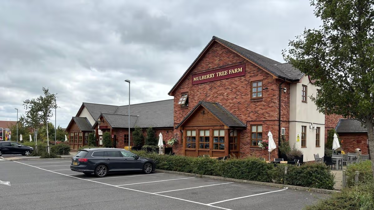
It will replace a pub which closed at the end of February
One of the UK’s most popular restaurant chains is set to open a branch in Cambridgeshire. Hickory’s Smokehouse is set to open the first of its kind in Cambridgeshire and is expected to create around 100 new jobs.
Advertisement
It will be located in Hampton, Peterborough, replacing a former pub called Mulberry Tree Farm. The pub, which closed on February 28, is currently undergoing a major refurbishment inside and out ahead of opening.
Hickory’s has confirmed its new restaurant is set to open early this summer on Kempley Close in Hampton. The new restaurant will include a mix of seating to suit every visit alongside a chef’s bar, where you can watch the chefs in action.
Outside will feature a secluded garden inspired by Southern outdoor living complete with a covered dining terrace ideal for the summer months. Additionally, a ‘neighbourhood bar’ offering a selection of cocktails, craft beer and their very own ‘Hickory’s Pale Ale’ will be on offer for guests to enjoy.
The bar will also have screens for the sport lovers to relish in with a drink in hand. A special feature for young guests includes a movie room where they can come and go as they please.
Advertisement
When it comes to the main event (the food), visitors will be able to indulge in their classics including Memphis ribs and 16-hour smoked Texas-style brisket. Their appetisers and desserts include Brisket Popcorn Bites and Frickles as well as their Peach Jam Jar Cheesecake and Table Toasted Campfire Marshmallow.
In their recent blog, it said: “Get ready to enjoy authentic flavours that’ll whisk you away on a journey into the hear of the Southern States.”
The modern-day food scene is no stranger to what you might call fads. Sushi tacos, Dubai chocolate, cronuts, cruffins, brookies: all manner of novelties that would make a time traveller from the 2000s scratch their head and shrug.
The same can perhaps be said of Manchester’s food scene. With the likes of Fat Pats (huge sandwiches weighing approximately the same as a small mammal), Get Baked (Matilda-inspired chocolate cake by the £20 slice) and Gooey (Hong Kong French toast), there’s no shortage of places turning new twists on old favourites into internet virality – and then real-life queues out the door.
Every year it seems like there’s a new trend you have to try – the tiramisu drawer, the £15 sub, hot chocolate served inside a biscuit cup…
Get MEN Premium now for just £1 HERE – or get involved in our WhatsApp group by clicking HERE. And don’t miss out on our brilliant selection of newsletters HERE.
Advertisement
So when a tantalising clip of a concept known as ‘sweet focaccia’ hit my Tiktok page this week, I can’t say I was surprised – but I knew I had to try it.
This newest Frankenstein creation comes from the team at Ferma pizza bakery. This Brewski off-shoot began life as Foldies, on Booth Street in the city centre and a stone’s throw from St Peter’s Square.
They’ve expanded from their folded pizza-style sandwiches to a whole range of pasties, muffins and sausage rolls, plus the full gamut of coffees, juices, crisps and snacks.
There’s also something interesting called a pizza bomb, a bready pocket stuffed with pizza toppings – and all made from pizza dough. That’s not what drew me there, though, but rather their focaccia offering.
Advertisement
Not just dotted with garlic and rosemary to be used as a sandwich, it’s now a vehicle for all kinds of customisable sweet toppings, from caramel/biscoff to Jammie Dodger, tiramisu and, inevitably, Dubai chocolate.
A quick Google tells me this idea isn’t exactly new, but it’s the first time I’ve ever heard of it. “Sweet focaccia?” I said to my boyfriend doubtfully on the phone on the way to the shop one Tuesday afternoon. “Will that really work?” But I would soon be eating my words.
Extremely hungry by 3pm, I looked over Ferma’s offering, which by then was some-what picked over by the crowd that had their lunch at a reasonable time. There wasn’t loads left, though the margherita pizza bomb sounded tempting – but then my eye fell on the shelf below, on a caprese focaccia sandwich approximately the size of a small book.
With just a few simple ingredients – mozzarella, tomatoes, pesto and rocket – this classic sandwich wasn’t about to set TikTok on fire. But I’m a believer that one of the best ways of judging a pizza place is to order a margherita; in other words, see if a place can get the essentials right.
And boy did Ferma get this one right. For £6.75, I’m served an absolute door-stop of a sandwich, two thick slices of focaccia whose crisp, flakey top gives way to a fluffy, airy interior which perfectly soaks up sweet balsamic vinegar and peppery olive oil.
Inside, there’s more peppery rocket, fresh tomato slices and creamy slabs of mozzarella topped with garlicky pesto. For the heft of the bread and the fresh, delicious simplicity of the filling, I’d be hard pressed to think of a better workday lunch.
Advertisement
Its sweet counterpart might have you falling asleep at your desk though. At £5.50, I opted for the caramel and biscoff version, and again my eyes widened at the size of the behemoth that awaited me in the box.
Another enormous slab of bread, this one looked positively obscene, positively swimming in biscoff and caramel sauce, topped with snowy mounds of cream and yet more biscoff drizzle and crumbs.
As to whether focaccia dough works in a dessert? I needn’t have worried – rather ask myself why no-one had thought of this sooner.
The soft, chewy dough – made every morning with a touch of cinnamon and caramel that gave it a warming, buttery note – was the perfect vehicle for absorbing all that addictively sweet Biscoff sauce.
Imagine a more cake-y cinnamon roll that actually soaks up the icing and toppings, rather than letting it meekly slide off.
After polishing off about half the portion, I was defeated, and took the other half home. But I’ll definitely be back to Ferma to try more, the next time I’m in town and need a fresh, tasty bite to keep me going.
Or I also might be paying another visit when I need a ridiculously indulgent but delicious treat to drown my sorrows in.
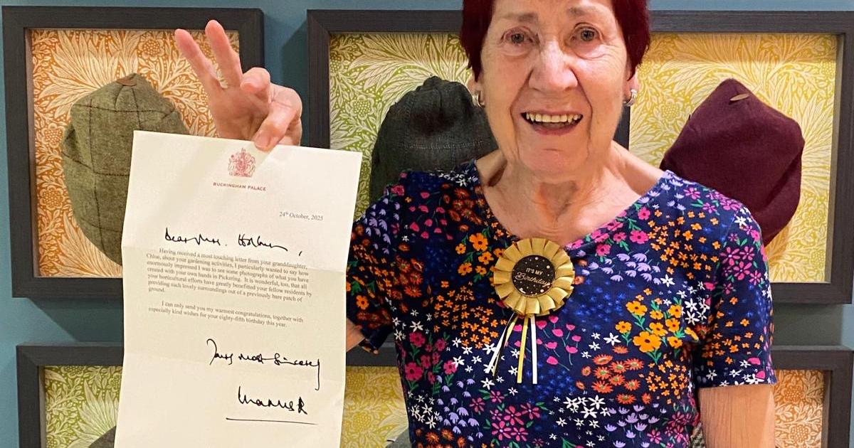
Lucy Holburn, 85, was one of the first residents to move into Mickle Hill, a retirement village for over-60s, nearly 10 years ago.
Since then, she has become known for transforming and maintaining parts of the village’s landscaped grounds.
Her long-standing commitment to gardening earned her a personal letter of recognition from King Charles in October 2025.
Advertisement
Ms Holburn said: “I’ve always been a really keen gardener, I find it so therapeutic and it allows me to take some time for myself and be at one with nature.
“Getting to be so creative is just wonderful, and the picturesque surroundings here lend themselves perfectly for having green fingers.
“The letter from the King means so much to me.
“Often my neighbours and friends compliment my gardening work, but having such a special message from the King was just brilliant.”
Advertisement
During the first Covid-19 lockdown, she completely transformed one of the hedgerows outside after having a chat with one of the gardeners.
Ms Holburn said: “Many residents said they found it uplifting to see the view outside their homes changing, during what was quite a dull time.”
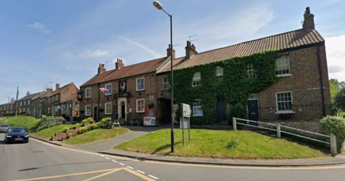
Stamford Bridge, which has the River Derwent running through it (located close to Dunnington), is said to feel “especially vibrant” during this time of year, according to London North Eastern Railway (LNER).
The travel experts shared about its latest seasonal guide: “Spring is the perfect time to explore somewhere new.
“The days are longer, the blossoms are showing off, and suddenly the urge to get away is impossible to ignore.
Advertisement
“So why not swap the usual rush for winding lanes, market squares and views that look like they’ve been freshly painted for the season?
“We’ve rounded up the UK’s best spring villages to visit by train, looking at everything from walking trails and nearby gardens to the variety of flowering plants and how easy it is to reach each village from the nearest train station.
“We also considered how each village comes to life in spring, from bursts of colour to those picture-perfect moments you’ll want to linger in a little longer.”
Why is Stamford Bridge among UK’s best spring villages?
LNER explained: “Just outside York, Stamford Bridge is a laid-back riverside village that feels especially vibrant in spring.
Advertisement
“The River Derwent runs right through it, with wildflowers lining the banks and plenty of spots to slow down and take it all in.
“The Stamford Bridge Nature Walk is a circular route linking the village’s two historic bridges, taking you along a stretch of river protected for its wildlife.
“Keep your eyes peeled, and you might spot kingfishers flashing across the water, swans gliding by or even the occasional otter along the banks.
“And the best bit? It’s an easy hop from York with a direct bus connection, perfect when you fancy swapping city buzz for something a little calmer, even just for an afternoon.”
Advertisement
Stamford Bridge is also home to Dreamery Gardens, which has been described as “the most magical day out”.
In a video on Facebook, Yorkshire-List.com shared: “If you’d like to get lost in the mystical world of forest fairies, then a trip to Dreamery Gardens is a must”.
“Situated just outside of York, you’ll find an enchanted wood home to forest fairies, elves and sprites, a whimsical afternoon tea and the country’s only fairy museum.
Advertisement
“Expanding over 100 acres, discover fairy villages, inhabited bridges and hobgoblin burrows, all set within the beautiful nature reserve home to over 100 species of birds.”
The Yorkshire content creator added: “After exploring the gardens, head to the Dreamery Kitchen, home to the most whimsical afternoon tea – a feast for the eyes and the hungry explorer.
“No matter the season, you’re sure to find magic around every corner at Dreamery Gardens.”
Just some of the other highly rated foodie spots in Stamford Bridge (according to Google Reviews) are The Three Cups, No. 10 Cafe Bar & Bistro and The Square Bakehouse.
Meanwhile, if you wanted to explore the village even further this spring, you might want to check out the Stamford Bridge and the River Derwent Circular.
Advertisement
This easy (and flat) walk rated 4.3/5-stars takes around an hour and a half to complete, and offers a combination of countryside and urban paths with views and historic sites.
Its AllTrails profile continues: “You will have the chance to explore the history of the village, including the site of the Battle of Stamford Bridge and the old rail line, plus a long peaceful stretch alongside the idyllic River Derwent.”
This person wrote in a review: “Nice easy walk with a mix of riverside, village lanes, farmland and woodland.
Expect a ‘long peaceful stretch alongside the idyllic River Derwent’ on this walk (Image: AllTrails/Hannah Kate)
“We were here on a weekday and hardly saw anyone else.”
Advertisement
Another posted: “A lovely walk, easy to find and very relaxing.”
One walker put: “Lovely easy stroll around the characterful viaduct and along the river.
“Free parking and plenty of cafe and pub options in Stamford Bridge. Around half is roadwalking, albeit quiet roads.”
It’s important to note that some of the paths can get muddy and slippery after wet weather, so wear appropriate footwear.
Advertisement
Will you be heading to Stamford Bridge this spring, including Dreamery Gardens? Let us know in the comments below.
He said it had lost about £25,000 annually since York City moved to the LNER Community Stadium – the fall in match-day trade had come amid a drop in footfall and interest generally, meaning the club was no longer viable.
Advertisement
January 1985 York City apprentices. (Image: The Press)
If that sad day comes, it will be the final chapter for a club which has been in the city for more than 100 years.
It seems fitting to look back and share some old photos from Bootham Crescent before the final whistle signalled the end.
York City fans clear snow at Bootham Crescent in readiness for the FA Cup. (Image: The Press)
Both Burton Lane Club and Bootham Crescent live on for many in their memories of great games, and past-match drinks – not least that incredible 1-0 victory over mighty Arsenal in the fourth round of the 1985 FA Cup.
Police keep fans off the pitch at York City’s FA Cup tie against Huddersfield Town on (Image: The Press)
Others still treasure items of memorabilia, sold off from what had been York City’s home since 1932 as housebuilder Persimmon looked to redevelop the site.
Advertisement
Football fans watching York City play Huddersfield Town in the FA Cup in 1938. (Image: The Press)
These Press archive photos focus on the ground itself, the grainy terraces pressed tight against terraced streets, the scarves lifted under winter skies, boots churning mud.
Straw being used at Bootham Crescent to protect the pitch from frost in 1985. (Image: The Press)
They may be a happy reminder for older readers of the massive crowd that turned out for the 1938 FA Cup tie against Huddersfield – 28,123 people which was a record attendance at Bootham Crescent.
A more unusual sight is our photo of straw laid out to protect the pitch from frost before City’s February 1985 FA cup tie against Liverpool – a game that ended in a 1-1 draw, before Liverpool went on to win the return leg 7-0 a few days later. Remember that?
York City fans in the car park at the Shipton Street end of Bootham Crescent in 1984. (Image: The Press)
Or perhaps you were one of the devoted fans pictured who helped clear snow from the pitch ahead of that famous Arsenal game?
Advertisement
We hope these photos bring back some happy memories…
WE hope you like our collection of historic photos of York.
If you love delving into York’s past and seeing photos and reading stories from yesteryear then make sure you check The Press every day for its regular nostalgia stories. And don’t miss our eight-page nostalgia supplement every Wednesday in the paper.
We also have more than 3,000 members in our online nostalgia group on Facebook, Why We Love York – Memories.
She has opened up about her brave battle to raise awareness and is now determined to help others
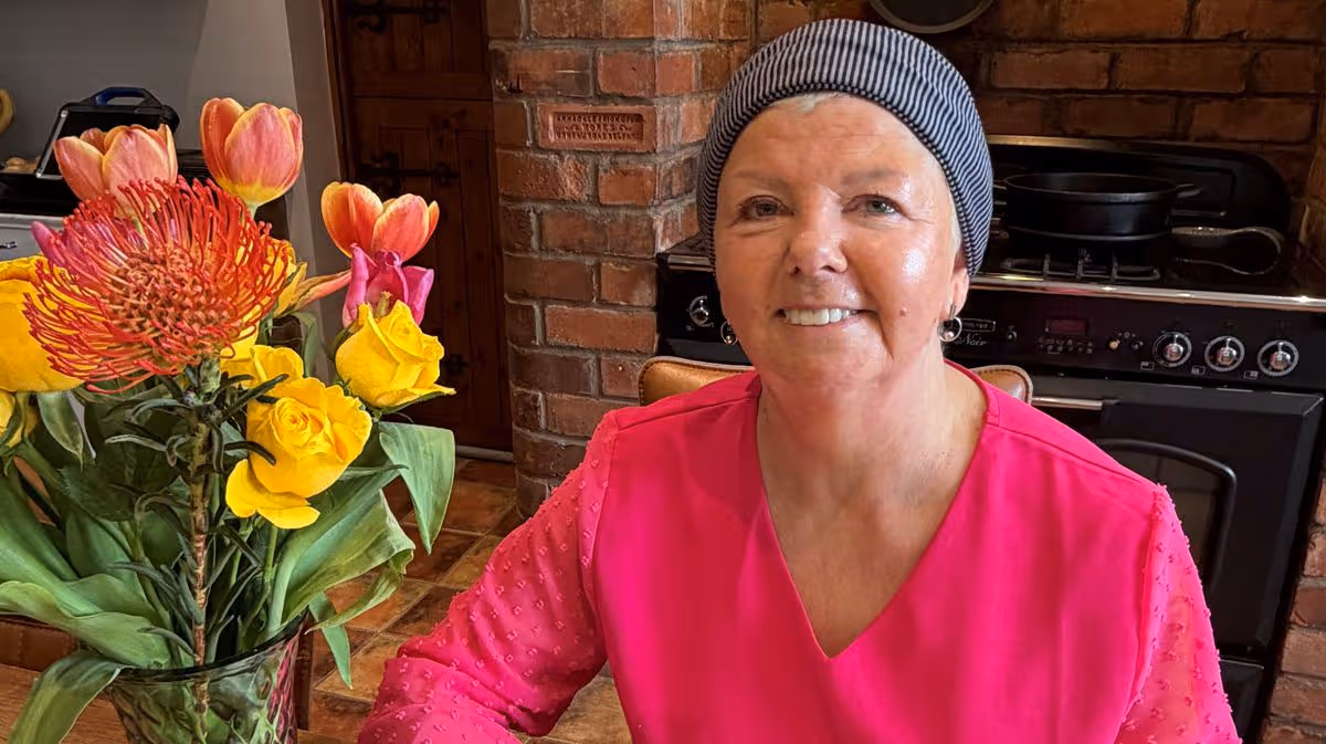
Mel’s shock multiple myeloma diagnosis
After months of unexplained pain and uncertainty, last May, Mel Walker received the devastating news that she had multiple myeloma.
Multiple myeloma is a blood cancer that affects plasma cells, a crucial part of the immune system. Symptoms can include persistent pain, fatigue, unexplained bruising or bleeding, frequent infections and bone damage, but they often start subtly, making the disease difficult to detect.
Diagnosis can take on average five months, longer than any other cancer. Multiple myeloma is the third most common blood cancer in the UK and Northern Ireland, with around 173 people diagnosed here each year. While it is currently incurable, it can be managed with treatment, care and ongoing support.
Mel’s journey began with persistent shoulder pain, but looking back, other warning signs were there, fatigue, ongoing discomfort and symptoms that were not improving. By the time she received her diagnosis in May 2025, Mel, from Comber in Co Down had developed blood clots and bone damage.
Mel explained: “The diagnosis was a huge shock. Before this, I had never even heard of multiple myeloma. I had a sense of fear and uncertainty, but also a feeling of relief at finally knowing what was wrong, after months of not knowing.”
Since her diagnosis, Mel has undergone chemotherapy, ongoing treatments and a stem cell transplant: “It has been physically and emotionally challenging, but I have responded well to treatment and I am now focused on recovery and raising awareness.”
Determined to make a difference, Mel has used her experience to campaign for greater awareness of multiple myeloma, including speaking out at Stormont to highlight the need for earlier diagnosis and improved understanding of the condition.
Mel is also part of a local support group, Myeloma Forward, with groups in Belfast and Ballymena, creating a vital network for people affected by the condition.
Recognising the importance of early detection, Mel hopes her story will encourage others to pay attention to their health: “Multiple myeloma is often diagnosed late because symptoms can be vague and mistaken for other conditions. Greater awareness, both among the public and healthcare professionals can make a real difference in outcomes.”
Advertisement
Mel has been fortunate to have had strong support from her family, friends, medical and nursing teams, which has been vital during treatment and recovery. Through Myeloma Forward, she is now helping others access that same sense of support and understanding.
She added: “It has been incredibly valuable to connect with others who understand this journey. Myeloma Forward offers a safe space to share experiences, advice and encouragement.”
South Eastern Trust, Haematology Clinical Nurse Specialist, Emma Kerrigan highlights the importance of being aware of the signs and symptoms of myeloma and seeking prompt medical advice.
Advertisement
She said: “Anyone experiencing persistent bone pain, extreme tiredness, recurrent infections and unexplained weight loss should speak to their GP without delay. Recognising these symptoms early can help speed up the diagnostic process and get onto the right management pathway.”
Mel also paid tribute to the team who have supported her throughout her treatment: “I cannot thank the staff at the Ulster Hospital enough. From the very beginning, they have shown care, compassion and professionalism. They supported me through every stage of my treatment and made an incredibly difficult time that bit easier.”
Encouraging others who face a diagnosis, Mel said: “You are not alone. A multiple myeloma diagnosis can feel overwhelming, but support is available and treatments are improving all the time. Take things one step at a time, ask questions and do not be afraid to lean on others. There is a whole community ready to support you.”
From April 6, some financial firms will be able to offer targeted support, giving people more tailored guidance on what to do with their finances, based on what the firm would typically recommend to others in similar situations.
Under the change, banks, pension providers and other authorised firms will be allowed to give suggestions aimed at groups of customers who share common characteristics, rather than only offering generic information.
This targeted support is intended to bridge the gap between broad, general guidance and fully personalised, paid-for financial advice, so that more people can make confident, informed decisions.
Advertisement
Customers will receive “ready-made” options designed for groups, without undergoing a full, in-depth assessment of their individual circumstances.
In December, the Financial Conduct Authority (FCA) said that at least 18 million people could be offered extra help with their investments and pensions over the next decade with the introduction of targeted support.
According to FCA data, around seven million adults in the UK with £10,000 or more in cash savings could be missing out on the benefits of investing throughout their lives.
Lucy Castledine, director of consumer investments at the FCA, said: “Too many people aren’t getting the help they need to navigate their financial lives.
Advertisement
“Without the right support to make decisions about their investments and pensions, many people risk falling short in retirement.
“Targeted support is designed to change that. It will help millions of people make better informed decisions and understand the potential rewards and any risks, including of not investing.”
Chira Barua, chief executive of Scottish Widows said: “The arrival of targeted support is a game changer for people who want help with their money but don’t know where to start.
“It bridges the gap between doing nothing and getting full financial advice, empowering millions to make better financial decisions.
Advertisement
“Technology will be key to making that support available at scale.
“Our AI (artificial intelligence) agent in the Scottish Widows app will work like sat nav, by helping people understand their options and choose a route that makes sense for them, based on others on a similar journey.”
A survey commissioned by KPMG UK found that more than two-fifths (44%) of people are confident they will use targeted support if it becomes available to them.
More than half (58%) of people surveyed said they have never sought professional advice on pensions or long-term savings and a similar proportion (53%) said they would welcome being offered targeted support.
Advertisement
Jane Wilson, targeted support lead at KPMG UK, said: “The fact that almost one in two consumers want to receive targeted support creates a once-in-a-generation opportunity to close the advice gap and support the UK’s ambition to create a nation of savers.”
KPMG found that of those consumers who have never sought professional financial advice, nearly a third (31%) feel they do not have enough money to make advice worthwhile, while around a quarter (26%) said it would be unaffordable.
When looking across the age brackets, people aged between 25 and 44 who were surveyed were most open to using targeted support, with 58% of 25 to 34-year-olds saying they are likely to use the support and 56% of 35 to 44-year-olds also saying this.
Those over 65 were the least inclined to access targeted support, at 22%, which KPMG suggested is driven by this age group being particularly likely to have already made pension decisions.
Advertisement
Ms Wilson added: “The notion that financial advice is only needed if you have notable wealth is simply not true; people with modest finances perhaps need support more than anyone else.
“Retirement no longer means handing in your lanyard and putting on your slippers; people work part-time, take on new challenges, or dip in and out of work to suit their changing lifestyles or meet their financial needs.
“The strong appetite for targeted support amongst the young shows there’s a chance to move people beyond saving and give them the confidence to invest for the long term.
Advertisement
“Done well, this can help individuals grow their wealth in line with their ambitions, while also channelling capital into the parts of the economy that drive sustainable growth.”
KPMG commissioned OnePoll to carry out the survey among 2,000 people across the UK in March.
Tom Shields, senior policy adviser, long-term savings policy at the Association of British Insurers (ABI) said: “We’re delighted to see targeted support now becoming a reality.
“After years of collaboration between industry, government and the FCA, this new approach is a significant step towards helping people get the support they need through their financial lives.
Advertisement
“We look forward to continuing to work closely with our members and the regulator as more firms bring the service to market.”
The Labour Mayor of York and North Yorkshire, David Skaith, has heralded a four-year transport capital funding settlement of £456 million as a “defining moment” for the region.
He added: “We’re moving away from short-term fixes and delivering the long-term solutions residents expect.
“We’re now in the driving seat with greater funding and local control that was previously out of reach and I’m investing a record amount to fix our streets and make them safer for everyone that uses them.”
Advertisement
York and North Yorkshire Combined Authority has agreed £298.4 million for highways maintenance and £17.5 million for active travel over the next four years.
An additional £30 million has been ringfenced for road safety work including improvements outside schools.
This pot also includes £2 million for the county’s first fixed and average speed cameras for the county.
Locations of the cameras would be determined by road safety partnerships.
Advertisement
For road maintenance, North Yorkshire Council will receive £63.8 million in 2026/27 — up from £57.8 million it received the previous year.
City of York Council will see its allocation rise to £7.1 million in the same period, up from £4.4 million in 2025/26.
But the decision on the settlement was taken without the support of North Yorkshire Council leaders who say their authority will receive around £20 million less over the four years than it would if the money came directly from the Department for Transport.
They are unhappy that extra money provided by the government has been “top sliced” by the mayor for other transport schemes.
Advertisement
They have also opposed a change to the calculation for road maintenance funding which means £4 million of their allocation will be diverted to City of York Council.
Conservative council leader, Councillor Carl Les, said: “To be clear, this is a decision made locally that will mean we have less money to maintain our roads.
“We had asked the mayor to reconsider the plans, and it is extremely disappointing that the proposals have now been voted through.
“There are no guarantees beyond the next financial year, and the allocations could change again to make the situation even worse.
Advertisement
“The approach actually risks a worsening rating for our highways from the Department for Transport, which could lead to a further reduction in funding.”
During the meeting at County Hall in Northallerton, North Yorkshire Council’s deputy leader, Councillor Gareth Dadd, questioned what data the Combined Authority had to support the introduction of speed cameras.
In response, Jo Coles, Deputy Mayor for Policing, Fire and Crime, said 2,000 people had been killed or seriously injured on North Yorkshire’s roads in the last five years.
She added: “Lancashire’s own introduction of fixed and average speed cameras, which I think is probably about ten years ago now, has had a significant impact on the numbers of people killed and seriously injured on the roads of Lancashire.”
Advertisement
Later in the meeting, the mayor stopped Cllr Dadd from speaking for a second time about the settlement.
In response, Cllr Dadd said it was “utterly disgraceful” that he was being “gagged” over the issue.
Both he and Cllr Les voted against the settlement.
But Councillor Peter Kilbane, deputy leader of Labour-led City of York Council, welcomed the extra funding for road maintenance for his authority.
Advertisement
He said: “Conservative Liberal austerity destroyed our roads.
“We are now setting about fixing them with that additional £105 million extra over that period. I think it’s bizarre that this has been resisted and spun as somehow being the worst thing that’s ever happened to North Yorkshire.”
Last year, a fixed speed camera installed as part of a trial on the A64 in Sherburn, between Malton and Scarborough, was deliberately knocked over hours before it was due to be switched on.
Sydney Sweeney starring as real-life boxing legend Christy Martin in the movie “Christy” and “Hacks” launching its fifth and final season on HBO are some of the new television, films, music and games headed to a device near you.
Also among the streaming offerings worth your time this week, as selected by The Associated Press’ entertainment journalists: Country hitmaker Ella Langley releasing her sophomore album, Nintendo dropping the monster combat game Pokémon Champions and “Malcolm in the Middle” fans getting a four-episode revival with Frankie Muniz, Bryan Cranston and Jane Kaczmarek.
New movies to stream from April 6-12
— Sydney Sweeney stars as real-life boxing legend Christy Martin in David Michôd’s “Christy” (HBO Max, Friday, April 10). The film, which Sweeney also produced, drew some of her best reviews. Her distinctly unglamorous performance spans Martin’s small-town West Virginia beginnings to a professional career shadowed by her abusive manager-turned-husband (Ben Foster). In her review, AP’s Jocelyn Noveck wrote that Sweeney “imbues her no-holds-barred portrayal of Martin with both sweetness and rage, with brio and real vulnerability.”
Advertisement
— One of the highlights of last year, Akinola Davies Jr.’s tender father-son drama, “My Father’s Shadow,” begins streaming Friday, April 10, on MUBI. The film, penned by Davis and his brother, Wale, is loosely autobiographical. Their father died when they were young. But in “My Father’s Shadow,” two Nigerian boys have unexpected day with their father ( Ṣọpẹ́ Dìrísù ) in Lagos, at a pivotal time for the country. In her review, AP Film Writer Lindsey Bahr called it “a gem, a deeply felt memory piece and vibrant portrait of Nigeria in 1993.”
— Jonah Hill made his directorial debut with the coming-of-age skate film “Mid90s.” He returns to directing in “Outcome,” a Hollywood satire starring Keanu Reeves as a movie star named Reef Hawk who fears a video could destroy his reputation. Hill, who co-wrote the movie, also co-stars as Reef’s crisis-management lawyer. It debuts Friday, April 10, on Apple TV.
— AP Film Writer Jake Coyle
New music to stream from April 6-12
Advertisement
— A chart-topping country hitmaker preps her sophomore album: Ella Langley — known for such radio mainstays like the throwback “You Look Like You Love Me” with Riley Green and the George Strait-referencing No. 1 “Choosin’ Texas,” co-written with Miranda Lambert — will release a new record on Friday, April 10. If the whole of “Dandelion” is anything like those songs, she’s got a long career ahead of her.
— The English disco-pop singer Jessie Ware will release “Superbloom,” also on Friday, April 10. She’s as ready to soundtrack a late night on the dance floor as she’s ever been — like on the single “Ride,” which interpolates the theme from the 1966 spaghetti Western film “The Good, the Bad and the Ugly” and melts into her sequined synths. “Come be my cowboy, baby, come, let’s ride,” she sings, more discotheque than honky-tonk. “You know I want you, I need you tonight, tonight.”
— AP Music Writer Maria Sherman
New series to stream from April 6-12
Advertisement
— “The Boys” launches its fifth and final season Wednesday on Prime Video. The critically acclaimed series is based on comic books and follows villainous superheroes and the crew trying to thwart them. Series regulars Jack Quaid, Karl Urban, Antony Starr, Erin Moriarty and Jessie T. Usher and Chace Crawford are all returning, as are more recent additions played by Jeffrey Dean Morgan and Jensen Ackles. “Hamilton” star Daveed Diggs also joins the cast.
— Hulu’s sequel to “The Handmaid’s Tale,” called “The Testaments,” also premieres on Wednesday. Ann Dowd reprises her Aunt Lydia character from the original and is now in charge of a school for girls that basically prepares them for adulthood, marriage and babies. These young women have never known anything other than Gilead. It stars Chase Infiniti and Lucy Halliday and is also based on a novel by Margaret Atwood.
— Elizabeth Banks and Matthew Macfadyen lead a new sci-fi comedy, “The Miniature Wife,” for Peacock. They play a couple working on their marriage when their lives are further complicated after an unusual accident. It premieres Thursday.
— Another series launching its fifth and final season is “Hacks” on HBO. The show, debuting Thursday, follows the love-hate relationship between a legendary comedian (Jean Smart) and a talented writer played by Hannah Einbinder. The series has racked up a lot of hardware, including an Emmy for outstanding comedy series. Smart has won four consecutive Emmys for the show while Einbinder has taken home one.
Advertisement
— Do you ever wonder how your favorite former TV stars would fare in the present day? “Malcolm in the Middle” fans are getting their wish. Twenty years after their show went off the air, Frankie Muniz, Bryan Cranston and Jane Kaczmarek return to TV for a revival where Muniz’s character is now a dad to a teenage girl. The four episodes of “Malcolm in the Middle: Life’s Still Unfair” premiere on Friday, April 10, on both Hulu and Hulu on Disney+.
— Alicia Rancilio
New video games to play from April 6-12
— Nintendo is pulling out all the stops to celebrate the 30th anniversary of Pokémon. Just a month after releasing the cozy community-builder Pokémon Pokopia, it’s dropping the considerably less comfortable Pokémon Champions. This time it’s all about the combat, as you recruit and train monsters before pushing them into the arena to fight other trainers’ creatures. You can compete in ranked events with players from around the world, or enjoy casual or private battles that won’t affect your ranking. It’s a free-to-start challenge, but you may want to set some cash aside for in-app purchases. The fight club opens Wednesday on Switch and Switch 2, with iOS and Android versions coming later in 2026.
Advertisement
— Annapurna Interactive’s People of Note tells the tale of a pop singer named Cadence who decides she wants to start a band. That means she’ll need to trek across the world of Note, where each city is defined by its own style of music. In her travels, though, Cadence learns that a Harmonic Convergence is disrupting music itself, and she and her bandmates will have to solve puzzles, explore dungeons and fight tone-deaf villains to stop Note from going silent. Los Angeles-based Iridium Studios promises that “each battle is an interactive musical performance,” and you can pump up the volume Tuesday on PlayStation 5, Xbox X/S and PC.
Hundreds of people lined the streets as a record-breaking 1,264 bikers arrived at Darlington Memorial Hospital.
Easter bunnies, Captain America, Cookie Monster and Minions were some of the bikers chosen attire for the feel-good ride which brought families and people of all ages together.
The streets of Darlington were filled with the sounds of revving engines, children screaming and shouting and dogs barking. In one word, excitement.
One child, upon seeing Captain America rev his engine, screamed: “I love you Captain America”, to which the Avenger gave a little salute.
Advertisement
Orgainsers said it was the biggest Durham Easter Egg Run yet (Image: Chris Booth)
Organiser Graeme Mills said he was “flabbergasted” by the number of bikes which turned out and thanked the public who lined the streets.
He said: “It was our biggest year ever, with 1,264 bikes. It has gone fantastic, that’s the only word I can say.
“I think this has been the biggest year for public support along the route. It makes it a spectacular event, and I am really pleased the public turned out to support in some not so good weather conditions too.”
Children and families lined the streets for the Durham Easter Egg Run (Image: Chris Booth)
The event has been a staple since 2005 when just a few hundred bikers took part, with the event getting bigger and bigger each year.
Advertisement
It took just under 30 minutes for all 1,264 bikers to make their way along Woodland Road, onto Hollyhurst Road and into the hospital.
The Durham Easter Egg Run outside Darlington Memorial Hospital (Image: Chris Booth)
The sun was shining on their arrival, as children and families got a glimpse of the bikes.
The bikers set off from the Durham Tesco in Dragonville at 10am, travelling en-masse to Darlington Hospital and arriving at about 11am.
The break meant children had a chance to see the bikes up close and personal and people could deliver Easter eggs to the children’s wards.
Advertisement
And Graeme spoke about the importance of the run.
“It has become an annual event. It does take a lot of organising, but the feeling you get as a biker is just really nice,” he said.
“Some of the team members have been around SEN groups and autism walks and given Easter eggs out. It pulls at your heartstrings when we get to do this.”
The sun was shining on the bikers as they rode into Darlington (Image: Chris Booth)
The hospital in Darlington was packed with a sea of bikes; there were that many bikes that some even parked outside the hospital.
Advertisement
Bikers handed out Easter eggs and let children sit on their bikes, and Graeme called it a “fantastic experience”.
He said: “Seeing the looks on the children’s faces, no words can describe it.
“A couple of years ago, we got absolutely soaked on the way down and my helmet was drenched. A kid wanted to try it on, and I did tell him how wet it was, but he put it on and was so happy.”
And Graeme thanked everyone who has donated eggs and money to the run this year.
Advertisement
The Durham Easter Egg Run outside Darlington Memorial Hospital (Image: Chris Booth)
The organiser said: “There are loads of supermarkets, members of the public who have supported us. We get more and more each year.
“The support of the Easter eggs for the kids in hospital, we could not do that without the public’s support. There are groups, workplaces that also collect Easter eggs to donate. It has become a long-established event, and it is being recognised for all the right reasons.”
Some of the charities benefitting from the run today include the Teenage Cancer Trust, British Heart Foundation, Feeding Families, and Missed A Beat, among others.
At the time of writing, nearly £4,000 has been raised on the GoFundMe page, with hundreds more expected from fundraising across the day.
Advertisement
You can donate to the fundraiser by visiting: www.gofundme.com/f/durham-easter-egg-run-2026.


You must be logged in to post a comment Login