The BBC has verified footage of several damaged hospitals, including the 17-story private Gandhi hospital in Tehran, close to the headquarters of the state broadcaster which was the target, a Red Crescent hospital in the town of Mahabad in western Iran, and a hospital in the southern port of Bushehr, from which babies in incubators were seen being evacuated on 3 March.
This pub offers reasonably priced food and drink across its menu
A bit of pub grub is always a fan favourite for people – and I’m one of them. While on a visit to Cottenham, I decided to see what food establishments they had on offer. There were a few cafes, but as that’s what I usually go for when eating out for lunch, I decided to change things up.
Advertisement
I came across the Waggon and Horses pub and decided to grab some lunch. I got a little bit lost on my way to the pub, as it is nested within lots of small streets. As I expected on a weekday lunchtime, I was the only customer, so I took a seat and began looking at the menu.
I was pleasantly suprised by the reasonable prices on the menu. The most expensive meals on the lunchtime menu were £6.50, and there were a few options available for this price. These options included scampi and chips, burgers, wraps and more. Some other meals priced at £5 included jacket potatoes and loaded nachos.
I decided to go for a basket meal for £6.50, which included chicken tenders and chips. The other option was chicken poppers and chips. I also chose to have melted cheese over my chips. For a drink, I chose an iced latte for £3.80, and paid an extra 50p to get vanilla syrup in it.
Advertisement
The pub itself offered a cosy vibe, with its fairy lights and fireplace. The pub is fairly small, but there is still plenty of space for several chairs and table. Only a few minutes later my iced latte came, and ‘oh my’ was my first thought. I expected a regular sized coffee, similar to a coffee shop.
But boy was I wrong! My latte came in a pint glass – I can’t say I’ve ever had a pint of coffee. Considering I paid the same price, or slightly cheaper than a coffee from somewhere like Costa or Starbucks, this was definitely a bargain latte. It was good too – I could really taste the vanilla and it satisfied my sweet tooth.
I was also impressed by the portion size of my £6.50 meal. I tucked into the chicken tenders which had a crunchy crisp to them. Just as their name suggests, the chicken was succulent and tender. I then tried some of the chips which were generously coated in cheese.
The cheese was very thick, but made the chips even better. The chips themselves were also very crispy, just how I like them. I must admit I struggled to finish my meal and enormous drink, and I was ultimately defeated. It was however a very satisfying meal, and safe to say it kept me going for the rest of the day.
Ultimately, the Waggon and Horses is an out-of-sight pub that offers great value food and drink. For coffee lovers, the pub is the perfect place to go with its pints of coffee.
All of our food reviews are paid for by the writer. The establishments do not know we will be reviewing their food, allowing us to make fair judgements on each place.
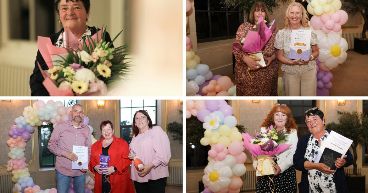
Stockton Council hosted the Foster Carer and Supported Lodgings Awards on Thursday, April 30, to honour the dedication and resilience of foster carers and hosts across the borough who support vulnerable children and young people.
Councillor Clare Besford, the council’s cabinet member for children and young people, presented the Long Service and Special Milestone Awards.
Cllr Clare Besford presenting a special milestone award to foster carers Colin Taylor and Pat Bond for 15 years of service (Image: Dave Charnley)
Cllr Besford said: “I’m immensely proud to celebrate our wonderful foster carers and supported lodgings hosts in our borough with these awards.
“It was an honour to celebrate their long and devoted service and hear about the outstanding achievements which they have made in the lives of children and young people in their care.
Advertisement
“Congratulations to all the winners and nominees.”
Foster Carer of the Year – Wendy Fowler (Image: Dave Charnley)
Carers and hosts were recognised across several categories, including long service, special milestones, and peer-to-peer support.
Special Milestone Awards were presented to those who reached one, five, 10, 15, and 20 years of service.
Long Service Awards went to those who had dedicated more than 30 years, including Margaret Wren (49 years), Malcolm and Shelley Atherton (33 years), and Patricia and Kenny Leishman (32 years).
Advertisement
Majella McCarthy, Director of Children’s Services with Foster Carer of the Year Wendy Fowler (Image: Dave Charnley)
The Young People’s Choice Award, with nominations submitted by children living with a foster family, was given to Sue and Stuart Reid in recognition of the support they provide to the young person living with them.
Julie and Paul Snowball received the Peer‑to‑Peer Recognition Award, which honours carers who support fellow foster families.
The couple play a key role in the Mockingbird fostering service, an extended family model designed to improve stability and outcomes for children by building a supportive community of carers.
Cllr Clare Besford presenting the 20 years of service award to Supported Lodgings Hosts Christine and Stephen Morgan (Image: Dave Charnley)
Julie Snowball said: “As I said on the night to the people who nominated me, it means the world to me but you are only as good as the people that you are surrounded by, and I’m surrounded by wonderful people, so it’s an honour for me to support them and I thoroughly enjoy doing it.”
Advertisement
Hazel and Wayne Micallef received the Supported Lodgings Host of the Year Award after being nominated three times.
The couple currently care for two teenagers, helping them build the confidence and skills needed for independence.
Foster Carer Julie Snowball, winner of the Peer-to-Peer Award with Louise Hollick, Assistant Director of Early Help, Safeguarding and Children (Image: Dave Charnley)
Supported lodgings hosts offer a home environment and practical guidance to young people as they transition into adulthood.
The Kinship Carer of the Year Award went to Pauline and Colin Poppleton.
Advertisement
Nominated by their grandchildren’s social worker, they were recognised for the emotional warmth, security, and sense of identity they provide, helping the children in their care make positive progress.
Wendy Fowler, who has spent more than 21 years as a foster carer, was named Foster Carer of the Year.
Ms Fowler said: “I was very surprised and quite emotional.
“From a personal level, it’s a great achievement for me, fostering is the best thing I’ve ever done in my life.”
Advertisement
She recently decided to retire due to health reasons.
Ms Fowler said: “I was very upset when I decided that I needed to retire, it took me a long time to think about it, but I thought the time was right because I hadn’t been very well last year.
“Now is the time to retire and spend a lot of time with my grandchildren and my children.”
Many of the children she has cared for over the years have remained in contact with her.
Advertisement
Ms Fowler said: “I’ve got other foster children as well because they stay in touch after all these years, they are still around and remain an important part of my life.
“I’ve loved every minute of fostering, and I would recommend anyone to do it because it gives more positives than negatives, it really does.”
For information on becoming a foster carer, visit the Foster with North East website.
Israeli broadcaster KAN has been given a warning ahead of the Eurovision semi-finals (Picture: Eurovision)
Israel’s Eurovision broadcaster has received a formal warning, just days before the contest kicks off in Vienna, Austria.
Participating broadcaster KAN was found to have violated the competition’s voting rules on Friday evening, as several promotional videos appeared on social media sites such as X.
In the clips, Israeli representative Noam Bettan encouraged viewers to use all 10 of their votes on Israel when he performs in the first semi-final on May 12.
The 28-year-old singer, whose song is titled Michelle, recorded the promo message in the languages of Azerbaijani, Dutch, English, French, German, Greek, Italian, Maltese, Portuguese, Spanish, Swedish, and Ukrainian.
Advertisement
Now, Eurovision Song Contest Executive Director Martin Green has confirmed that KAN has been reprimanded.
In a statement shared with Metro, he said: ‘We were made aware that videos instructing viewers to vote 10 times for Israel had been published and distributed by the artist representing KAN.
Advertisement
‘Within 20 minutes, we had contacted the Israeli delegation and asked them to immediately stop all distribution of the videos and remove them from all platforms where they had been published. They did so.’
He added: ‘We will continue to closely monitor any promotional activity and take appropriate steps as necessary.’
In response, KAN reported that the campaign isn’t financed by any particular group, claiming that Eurovision fans are the ones choosing to support their entrant.
Advertisement
They insisted that they would always abide by the rules of the EBU (European Broadcasting Union).
Last November, the EBU implemented changes to the voting rules to ‘strengthen trust and transparency’.
In a major overhaul of the voting framework, the new measures followed extensive consultations after the 2025 contest in Basel, Switzerland.
Noam Bettan will represent Israel with the song Michelle (Picture: Instagram)
Several of his promo videos have surfaced on social media, which violate voting rules (Picture: Instagram)
In-depth reviews were carried out in collaboration with participating broadcasters and other event organisers, who offered feedback to help prevent rule breaks and strengthen the voting system.
Green said at the time: ‘We’ve listened and we’ve acted.
Advertisement
‘The neutrality and integrity of the Eurovision Song Contest is of paramount importance to the EBU, its members, and all our audiences. It is essential that the fairness of the Contest is always protected.
‘We are taking clear and decisive steps to ensure the contest remains a celebration of music and unity. The Contest should remain a neutral space and must not be instrumentalised.’
Green added that, alongside the changes announced, there was a new commitment to ‘strengthening the enforcement of existing rules’ to ‘prevent any misuse of the Contest’, for example, through ‘song lyrics or staging’.
‘We will work closely with members to ensure they fully understand and are also accountable for upholding the rules and values that define the Song Contest.’
Advertisement
The EBU has faced calls to ban Israel from the contest for the past three years (Picture: Harold Cunningham/Getty Images)
Both pro and anti-Israel demonstrators staged protests outside the arena in Basel last year (Picture: Fabrice Coffrini/AFP via Getty Images)
In total, there were four changes made. The first was ‘clearer rules of promotion’, forbidding participating broadcasters, such as KAN, and artists, such as Bettan, from ‘actively engaging in, facilitating, or contributing to promotional campaigns by third parties that could influence the voting outcome’.
The EBU stated that ‘any attempts to unduly influence the results will lead to sanctions’.
Secondly, Eurovision bosses reduced the maximum number of votes. For 2026, fans will only be able to vote through phone calls, SMS, or online 10 times, reduced from 20.
‘Fans will be actively encouraged to share their support across multiple entries,’ the changes stated.
Thirdly, the return of professional juries of music experts for the semi-finals was confirmed for the first time since 2022. This creates ‘a roughly 50/50 split between jury and audience votes’ in the final.
Advertisement
The EBU explained that this change ‘is intended to encourage the optimum musical balance and diversity in songs that qualify for the grand final, ensuring that high-quality entries with broad artistic merit are recognised alongside those with popular appeal’.
The United Kingdom will be represented by Look Mum No Computer for 2026 (Picture: BBC/Michael Leckie)
In turn, the number of jurors has been increased from five to seven, and the pool has been expanded to include journalists, critics, teachers, choreographers, and stage directors.
Each jury must now also include at least two jurors aged 18 to 25.
‘All jurors will have to sign up to a formal declaration to confirm they will vote independently and impartially, will not coordinate with other jurors before the contest, and will be mindful of their social media use,’ organisers stated, which means not voicing voting preferences online before the end of the contest.
Are you watching Eurovision or boycotting this year?
Want to get bespoke updates on the TV shows you love? Sign up to Metro’s TV newsletters and tell us which ones you can’t get enough of
Advertisement
Finally, technical safeguards have been ‘enhanced’, meaning the EBU will ‘work closely’ with its voting partner to prevent fraudulent or coordinated voting activity and to closely monitor suspicious patterns.
Green further stated that the new measures are ‘designed to keep the focus where it belongs – on music, creativity, and connection’.
The contest will be held in Austria this year, following JJ’s win in 2025 (Picture: Hans Klaus Techt/APA/AFP via Getty Images)
Chair of RTVE José Pablo López said in a statement: ‘As joint organisers of the Eurovision Song Contest, we share a collective responsibility. While Israel has regularly participated in the competition, the current events and the genocide currently taking place make it impossible for us to look the other way.
‘It is not accurate to claim that Eurovision is merely an apolitical music festival. We are all aware that the contest carries significant political implications. The Israeli government is equally aware of this fact and leverages the event on the international stage.’
For the past three years, despite outside pressure following the Gaza conflict, the EBU has allowed them to remain in the contest.
This sparked particular fury given how, despite proudly declaring to be ‘apolitical’, the contest banned Russia from taking part in 2022 after the invasion of Ukraine. This was decided after other participating nations threatened boycotts.
There has been much speculation about why the EBU has refused to ban Israel, including the fact that one of Eurovision’s most prominent sponsors is the Israeli beauty brand Moroccanoil.
Advertisement
Got a story?
If you’ve got a celebrity story, video or pictures get in touch with the Metro.co.uk entertainment team by emailing us celebtips@metro.co.uk, calling 020 3615 2145 or by visiting our Submit Stuff page – we’d love to hear from you.
Police were called to a shop on High Newham Court in Stockton at around 3pm on Friday (May 8), following reports of a ‘disturbance’.
The men are reported to have made threats to staff and then fled the scene.
Police arrived on the scene and arrested three men, two aged 32 and a 40-year-old and a woman, aged 62, was arrested and taken to police custody.
Advertisement
One of the 32-year-olds was arrested on suspicion of assisting an offender and drink driving.
Cleveland Police have launched an investigation into the incident.
Detective Chief Inspector John Bonner said: “At approximately 3pm on Friday, May 8, police were called to a shop on High Newham Court in Stockton following reports of men armed with a machete and a bat.
“The men are reported to have made threats to staff.
Advertisement
“Officers, including armed response, attended to the scene.
“Enquiries led officers to stop a vehicle where four people were detained.
“Three men, two aged 32 and a 40-year-old and a woman aged 62 were arrested and taken to police custody.
“One of the 32-year-olds was arrested on suspicion of assisting an offender and drink driving.
Advertisement
“If anyone saw the incident take place and has information or footage, please call 101 or visit our website quoting reference number 087218.”
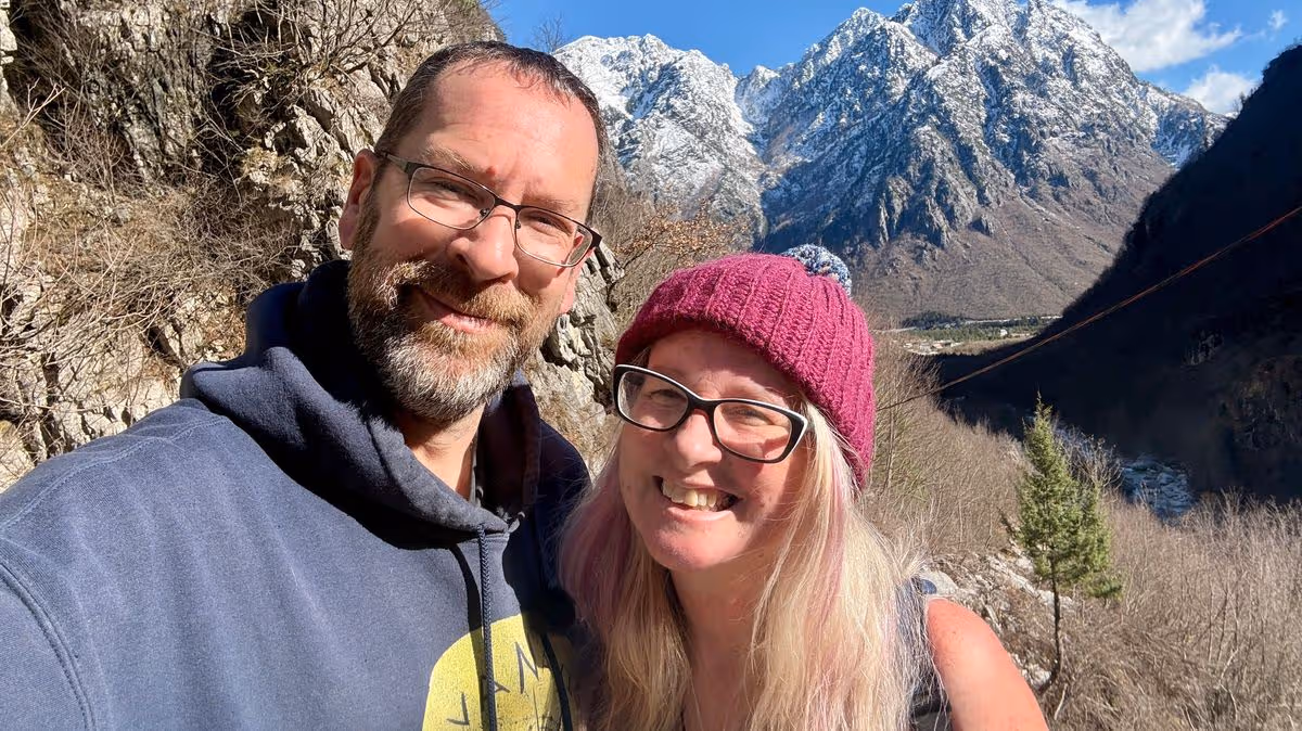
Kath Cross sold all of her possessions and now drives across the world with Stuart Hall
Howard Lloyd Regional content editor
13:07, 09 May 2026
A couple sold all their possessions to buy a campervan and travel the world – for just £30 a day. Kath Cross, 49, and Stuart Hall, 48, have travelled over 25,000 miles on epic adventures through the Sahara desert, Europe and Scotland in their make-shift home.
The pair have been living in their 7.5m Mercedes Sprinter ever since Kath sold all her possessions and stopped paying rent four years ago. To date they have toured over 15 countries – and will have exceeded 20 by the time they get back from their current trip to Montenegro.
Advertisement
The couple work on the road full-time under the name Vanavigation – where they create, write and share travel content. Though their spending plan varies slightly depending on which country they are residing in, the pair say on average they spend around £900 to £1,200 a month – cheaper than Kath’s old house rental in Cardiff.
This means they budget around £30 to £40 a day for their lifestyle – with half spent on fuel. Kath, from Cardiff, said: “It was a choice we made between one life and another – and we don’t regret a second of it.
“When I sold my possessions, it made me realise that you are supposed to own things – not them own you. When you have a mortgage, a car payment, you are owned by society, fixed because you have to stay where you are and pay your bills.
Advertisement
“The more of my stuff I sold the more free I felt – the more I am realising those possessions owned me and pinned me in one place. Life owns you and you are supposed to own it.”
Kath and Stuart bonded over their shared love of nature and the outdoors after meeting in a South Wales walking group back in 2021. They hiked over 105 peaks in the UK during their first year of dating and Kath decided that Stuart was the person she wanted to travel the world with.
She soon after decided to pack up her four-bed rental house and sell all of her possessions back in 2022 when her daughters left home. Stuart and Kath have since travelled over 25,000 miles – including their first trip all the way to the Sahara desert, which Kath described as her “lifelong dream”.
Kath said: “I had an idea that when my kids left home I wanted to drive to the Sahara – it was a dream I’d had for years. Stu already owned the van, and we had been together a few months when we visited Scotland for a month in the campervan. We didn’t kill each other and got on very well.
Advertisement
“So that winter I decided that I was going to downsize my life, my kids had left home, the four-bed rental was too much for me and I just didn’t want it anymore. It was taking every penny that I earned just to keep the rental going – but we knew we could live cheaper on the road.
“A lot of people are scared of the big adventure, but Stu was up for the idea and so we drove to the edge of the Sahara desert and haven’t looked back.”
The mother-of-two is able to ensure a steady monthly income for the pair after she set up her own business online back in 2012. As a single parent, Kath wanted to ensure she could earn a living while being at home with her children – and her copywriting and freelance work saw her amass 1.6million followers on Facebook in 2014.
Advertisement
Stuart, who works for an agency as a truck driver, works when they visit the UK after trips to help top up their money before their next adventure. Her and Stuart are both work together to produce content for Vanavigation – releasing weekly Youtube episodes, travel guides and insightful blogs across social media on how to travel the world.
Kath said: “Life really is a lot cheaper in the van – you don’t need two wages. We were away for 101 days and our average spend was £1000 a month – this is less than my rent used to be in Cardiff and we lived like kings and queens.”
Despite more than half their budget being on fuel, the pair say they don’t live like they are on holiday – and mostly cook in the van and only pay for a few activities a month. Kath said: “As fuel prices have gone up we have just slowed down!
Advertisement
“We just drive a bit slower and make a few less stops – which means we extend the trip really. When you’re in North Macedonia and paying 130 a litre for diesel, there is no point rushing back to pay whatever horrifying price it is in the UK at the moment.”
The pair are able to live in their fully-equipped campervan which boasts a full working set up including: a shower, toilet, king-size bed, sink, and a fully working kitchen with an oven, gas burner. Stuart, who converted the inside of the van shortly after purchasing it, said: “We can even do a roast dinner.”
So far, the pair have driven 3,000 miles to Denmark and back, 7,000 miles around Spain and Portugal, 2,000 miles to Scotland and 8,000 miles to the Sahara. They are currently in Montenegro, and are just shy of 5,000 miles on their trip which has seen them drive through France, Italy, Albania, Greece, North Macedonia and Kosovo.
Their next stops are Serbia, Bosnia, Croatia, Slovenia and France. Kath and Stu said their Sahara trip has been one of their many highlights – which also include their visit to the Atlas mountains, Kosovo and Denmark.
Advertisement
Stuart, from Southampton, said: “We drove to the edge of the sand dunes and were drinking coffee out of own mugs from home. Then we opened up the curtains and there were 40 camels outside – it was totally surreal. I had only ever been on package holidays before.”
Kath said they also loved their visit to the Atlas mountains because of the scenery and people they met during their trip and volunteering. She said: “There are communities there that have nothing, and they just want to help you.
“We helped a guy stuck in the snow and he wanted to take us to his village, which had 66 houses and a mosque. His family made us food and drinks and the kids in the village came to meet us and it was only a few months after the earthquake. It was so special connecting with the local communities.”
The pair are strong advocates for following your dreams and travelling the world in a mindful and sustainable way. Stuart said: “We choose to step lighter on this earth.
Advertisement
“My big diesel van has much less of a carbon footprint than a three-bed house where people leave the lights on. We don’t buy new stuff, we wear clothes until we can’t wear them anymore and we live light on plastics. We love this life and we learn so much about people.”
Kath said: “You can’t dream yourself into this life, you have to make intentional decisions to get here. You have to let go of other things to get here. We left the rat race – and we’re really glad about it.”
You can follow their adventures here: “https://www.facebook.com/vanavigationuk/
1.6 million elderly people get Attendance Allowance as it stands, but there are plenty more who could claim it.
The finance expert explained how to ensure ‘backdated’ payments that start accruing from the original date of claim and not when the DWP officially processes the paper-toting application.
Mr Lewis said: “Call for the form because then they (DWP) send you a form and you apply but you get paid from the date you called up for the form.
Advertisement
Do you pay energy by monthly Direct Debit? If so this is the perfect time to check if you’re due £100s credit back.
“If you download the form off GOV.UK and your claim is successful, you get paid on the day you sent it back to them and there could be at least eight weeks difference in that, so call for the form.”
He recommended that anyone seeking further advice on making a claim or requiring assistance with the application form should get in touch with Age UK at 0800 678 1602, which operates daily from 8am to 7pm.
Advertisement
He went on: “Fill in the form with as much detail as possible. Age UK is brilliant on this, they’ve got a brilliant helpline that will probably be swamped but it’s open during the days, but they’re really professional at helping you fill out the form so those who are entitled get the money and don’t fall foul for some strange reason.”
Money Saving Expert explained: “Attendance Allowance is one of the most underclaimed benefits, with as many as 1.1 million missing out on up to £5.2 BILLION a year, according to estimates from MoneySavingExpert and Policy in Practice.
“If you’re aged 66+ and need help with daily living due to illness or disability, check if you’re due £5,645 a year…”
Attendance Allowance is a non-means-tested weekly payment to help cover the costs of pensioners (aged 66+) who need someone to ‘attend’ them.
He was the driver of the only vehicle involved in the collision
12:34, 09 May 2026Updated 12:41, 09 May 2026
A man in his 20s has died following a motorbike crash in Co Wexford on Friday, Gardai said.
He was the driver of the only vehicle involved in the collision on the L4016 near Glenour, in Adamstown.
In a statement, An Garda Siochana said it happened at about 9.20pm on May 8 and the man was pronounced dead at the scene.
Advertisement
His body was taken to University Hospital Waterford where a post-mortem examination will take place.
The road is closed for forensic examinations and local diversions are in place.
Issuing an appeal for information, an Garda Síochána spokesperson said: “Any road users who were traveling on the L4016 between 9:00pm and 9:30pm on Friday 8th May 2026 are asked to make contact with investigating Gardaí. Anyone with camera footage (including mobile phone or dash-cam) is asked to make that footage available.”
They added: “Anyone with any information is asked to contact New Ross Garda Station on (051) 426030, the Garda Confidential Line on 1800 666 111, or any Garda Station.”
The farm is proposed on land south of the A10 Cambridge Road in Stretham. If approved, the solar panels will be installed for a temporary period of 40 years.
After this, the panels will be decommissioned and the land will return to agricultural use. The solar farm, which would be set over 43 hectares, is projected to export up to 100 megawatts of electricity.
Other solar farms and energy-producing sites in the surrounding area have been previously approved. This includes one on land south west of Stow Bridge Farm in Newmarket Road in 2012, another in Green End in 2014, followed by another two in 2016 and 2023.
The applicant said it was “clear” that the surrounding area has been subject to a “number of energy related planning applications”. As well as the panels, the plans also seek to add security fencing, CCTV, storage buildings, a battery energy storage system, access tracks and more.
Advertisement
Existing hedgerow and plants that are already on site are set to be retained in the proposals. The site falls mainly on flood zone 1 land, meaning it is unlikely to flood.
However, there are “very small areas” that are flood zones two and three. The applicants do not believe the site would produce any harmful emissions or noise pollution.
It’s not also expected to “generate significant waste during construction or operation”.
Hakimi was expected to miss the rest of the season with doubts even emerging over his partitcpation in this summer’s World Cup campaign.
Advertisement
But according to RMC Sport, the former Real Madrid and Inter Milan star is recovering well and is expected to ready for the final in Budapest on 30 May.
PSG are also likely to be boosted by the availability of goalkeeper Lucas Chevalier. An injury suffered in training last week also raised fears his season could be over but the report states he too hopes to be available for the showdown with the Gunners.
Chevalier was signed from Lille last summer to be the new no1 with Gianluigi Donnarumma leaving the French capital to join Manchester City.
Hakimi was on the pitch to celebrate with his teammates on Wednesday (Picture: Getty)
Matvei Safaonov however has been starting ahead of hm since January, overtaking him in the pecking order.
Should Hakimi recover in time and avoid any more injury scares, PSG will have a fully fit squad to choose from when they meet Mikel Arteta’s side at the Puskas Arena.
Advertisement
Arsenal have concerns at right-back themselves over Jurrien Timber.


You must be logged in to post a comment Login