


It comes after a record breaking month of June on the weather front thanks to the recent heatwave
It’s the first weekend of July after a record breaking month of June on the weather front as the recent heatwave brought a run of sweltering days and balmy nights.
A punishing heatwave affected many parts of the country during the last week of the month, with temperatures topping 30C somewhere in the UK for seven days in a row from June 21-27.
Northern Ireland and Scotland both saw their joint fourth warmest June.
The mean temperature across the UK was 15.6C, ranking behind only 15.8C in 2023, according to figures published by the Met Office.
The exceptionally hot and humid conditions in the last week of the month led the Met Office to issue a rare red warning for extreme heat for much of southern England and south-east Wales.
The warning ran for three consecutive days – the longest period of time such an alert has been in place.
Dr Emily Carlisle, of the Met Office, said: “June’s high temperatures are part of a broader pattern of warmth during 2026. So far, five of the first six months of the year have recorded mean temperatures at least 1C above average, with only January seeing below-average temperatures.”
Scientists warned the severity of last month’s heatwave – which affected much of mainland Europe as well as the UK – would have been virtually impossible 50 years ago.
This year is shaping up to be a multiple record-breaker for heat in the UK.
As well as the highest peak June temperature since Met Office data began, 2026 has also seen the highest May temperature on record, with 35.1C measured on May 26 at Kew Gardens in London.
England and Wales both experienced their warmest spring on record in 2026, thanks partly to the heatwave that hit the UK at the end of May.
Sunshine totals in June were above average for the UK, England and Wales, although “not by as much as might be expected” given the intensity of the heat, the Met Office added.
The high humidity “meant skies were often hazier and cloudier than during a less humid heatwave, limiting sunshine totals despite the exceptional temperatures”.
Northern Ireland and Scotland recorded below average sunshine totals.
Despite the exceptional heat, June was wetter than average for the UK and all four nations, due to a series of low-pressure weather systems earlier in the month that brought cloudy and unsettled conditions to many areas.
Here’s what we can expect over the coming days.
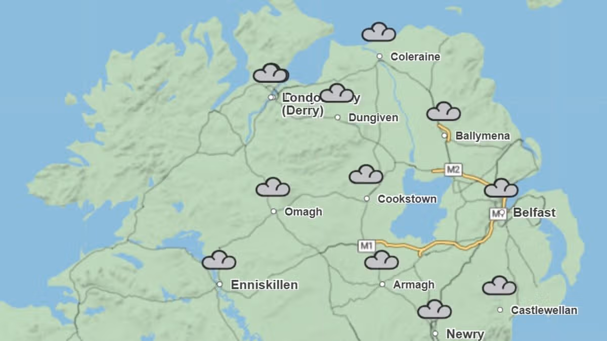
Saturday:
A mainly dry and cloudy day with just the odd shower, although these may become more widespread in the west later. Some occasional brightness in the southeast. Maximum temperature 19°C.
Outlook for Sunday to Tuesday:
A changeable, often cloudy and breezy few days with spells of rain, but some drier and brighter periods too, especially in the east.
UK long range weather forecast: Wednesday 8 July – Friday 17 July
High pressure will dominate across England and Wales into next week, likely extending its influence into the northern UK with time. This will bring dry and warm conditions with plenty of sunshine for much of England and Wales, but there is a chance of thunderstorms at times.
Scotland and Northern Ireland will see more cloud at first, with periods of rain at times. Through next week the high pressure may extend northwards to bring periods of drier and warmer weather to most of Scotland and Northern Ireland.
Winds will be light to moderate for most, though stronger around northern hills and coasts near low pressure systems. Temperatures becoming widely warm, perhaps locally hot in parts of the southeast, although not as hot nor humid as seen in the past week.
For the latest top stories, visit the Belfast Live homepage here and sign up to our daily newsletter.


You must be logged in to post a comment Login