Britain faces thunderstorms and flooding today after some areas experienced their first rain in two months – but wildfires continue to ravage drought-hit areas.
Parched southern England finally saw downpours this morning after 60 days without rain during successive extreme heatwaves and exceptionally dry weather.
Forecasters warned of localised flooding but said the rain would not mark an end to the drought conditions across nearly three-quarters of England and all of Wales.
The Met Office confirmed the overnight rain saw Wisley in Surrey break its 62-day dry streak, the longest of any area in the UK, with 1.6mm falling in the early hours.
Other locations seeing their first rain after a long time included London Heathrow Airport and Odiham in Hampshire after 56 days, and Preston in Dorset after 53 days.
Up to 23mm (0.9in) of rain fell in Merseyside in the 12 hours to 6am today; while up to 13mm (0.5in) fell in Northern Ireland and 10mm (0.4in) across south-west England.
The Met Office has also issued three separate yellow thunderstorm warnings for the UK – in Northern Ireland from 12pm today until midnight; northern England from 7pm today to 10am tomorrow; and north-east Scotland from 2pm to 9pm today.
Meanwhile fire crews continued to battle a peatland blaze which started 11 days ago at Holme Fen near Peterborough and now measures around 60 football pitches.
Kent was also particularly badly hit by further wildfires, with six fire engines battling a huge blaze on a farm in St Margaret’s-at-Cliffe near Dover at 8pm last night.
Grass also caught fire at Mote Park in Maidstone at 7pm, after a separate blaze on a field at Iwade near Sittingbourne sent black smoke billowing into the sky at 6pm.
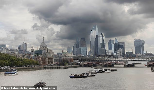
Dark clouds over the City of London this morning, as photographed from Waterloo Bridge
Storm clouds gather over Cullercoats Bay and Tynemouth in North Tyneside this afternoon
Swimmers take an early morning dip in the sea today after West Bay in Dorset finally sees rain
The Met Office has issued three separate yellow thunderstorm warnings for the UK today
Elsewhere Kent Fire and Rescue Service used hose-reel jets and beaters to put out another fire in Gravesend after grass and bushes went up in flames at 4.30pm.
Twenty miles away in Deptford, 100 firefighters from the London Fire Brigade battled a blaze involving 50 tonnes of household waste at a recycling facility overnight .
Wildfires have swept across parts of the UK following the hot and dry summer, including in the West Midlands where a blaze in Stourbridge destroyed 19 homes.
The National Fire Chiefs Council said England and Wales has had 1,132 wildfires in 2026 so far – a record high for the amount between January and this time of year.
Several fire services have asked people in recent weeks to call 999 only to report a genuine emergency, and millions of people in England and Wales received an alert on mobile phones last Friday warning them of a ‘very high risk of wildfires nationally’.
Areas with the longest dry streaks in summer
- Wisley, Surrey: 62 days
- Heathrow Airport, London: 56 days
- Odiham, Hampshire: 56 days
- Preston, Dorset: 53 days
- Farnborough, Hampshire: 52 days
- Coningsby, Lincolnshire: 51 days
- Northolt, London: 51 days
- Andrewsfield: 50 days
- Shoeburyness, Essex: 49 days
- Kew Gardens, London: 49 days
<!- – ad: https://mads.dailymail.co.uk/v8/de/news/none/article/other/mpu_factbox.html?id=mpu_factbox_1 – ->
One of the biggest wildfires was near Aviemore in the Cairngorms, where crews completed work this week to tackle it nearly five weeks after it began on July 15.
A summer of heatwaves and dry weather has left many areas facing an elevated wildfire risk as well as water shortages, with nearly three-quarters of England and the whole of Wales now in drought.
But the Met Office said some areas of the country were finally seeing the ‘first meaningful rain for a long time’ this week.
The UK will experience showers over the coming days, although a forecaster said the rain is ‘not going to solve the drought situation overnight’.
The rainfall is not expected to be a ‘huge amount’ and ‘highly hit and miss from place to place’, before conditions became drier again over the weekend.
Met Office meteorologist Aidan McGivern said today would be a ‘very showery day’ across the UK, with Northern Ireland and areas in western and central Scotland seeing ‘frequent showers with heavy downpours, hail and thunder’.
The showers would be ‘fewer and further between’ in southern areas, while central England and eastern Wales could still see some downpours, the forecaster added.
He said: ‘I suspect many people across England and Wales will at least enjoy the feel of some rain falling out of the sky during the next few days, but it’s not going to solve the drought situation overnight because we’re not expecting huge amounts and it will be highly variable because a lot of it will come in the form of showers.’
Highs of 25C in London, 20C in Cardiff, 19C in Manchester and 16C in Glasgow are expected today.
Straw bales alight during a huge wildfire on a farm in St Margaret’s-at-Cliffe, Kent, last night
Emergency services on scene during a wildfire in St Margaret’s-at-Cliffe near Dover last night
A major fire burns at a recycling facility in Deptford, south-east London, last night
Firefighters continue to tackle a fire at Holme Fen Nature Reserve in Cambridgeshire today
Tomorrow will begin with some ‘very heavy rain’ across parts of northern England and north and west Wales with frequent showers in the southwest, Mr McGivern said.
That afternoon will bring a ‘better chance’ of showers further south and ‘dumping a reasonable amount of rain in places’, he added.
‘But again, because they’re showers, it will be hit and miss, very speckled in nature,’ he said.
Temperatures will be below average for a large part of the UK tomorrow, which is ‘something we’ve seen on only a handful of days this summer,’ the forecaster continued.
The Met Office also warned that ‘localised flooding cannot be ruled out beneath the heaviest downpours’, but added: ‘Rainfall is expected to be variable in nature, with many places also experiencing drier interludes between showers.’
Looking further ahead, its outlook said meteorologists were expecting a ‘continuation of the more unsettled conditions that have developed this week’.
Rain and showers are ‘likely to remain a frequent feature through the remainder of August’ and ‘temperatures will generally be close to average but with occasional warmer spells’.
Into early September, Met Office forecast guidance suggests ‘wetter-than-average weather remains more likely, particularly across northwestern areas of the UK’.
The weather service added: ‘A northwest to southeast split appears the most probable pattern, with the northwest generally seeing more unsettled conditions and the southeast enjoying the greater chance of drier weather.
‘The long-range outlook also indicates temperatures may trend above average later in the period, although confidence in any specific hot spell or heatwave remains low at this range.’
Meanwhile water companies could be forced to reduce the amount they take from the River Severn to prevent parts of it drying out in the ongoing drought.
Cheltenham Racecourse from Cleeve Hill in Gloucestershire in March (left) and today (right)
Satellite images show how weather conditions have changed significantly over the past week
Rain begins to fall yesterday over the drought-hit Hollow Pond in Leytonstone, east London
The Environment Agency and Natural Resources Wales have applied to the English and Welsh governments for a drought order for the River Severn, warning of the impact the conditions are having on the Severn’s habitats and surrounding farmers.
If granted, it would require Severn Trent Water, South Staffordshire Water, Bristol Water and Hafren Dyfrdwy, to reduce the amount they abstract from the river by 5%, which they have said will not affect water supplies.
The order would also impose a cap on the amount of water the Canal and River Trust could take for the Gloucester and Sharpness Canal and reduce releases from a reservoir at the river’s headwaters to stretch the amount of available water over a longer period to support fish and other wildlife.
As the Environment Agency announced the application for the drought order for the Severn, a spokesperson said: ‘We are exceptionally concerned about the impact that the drought is having on the River Severn’s habitats and surrounding farmers.
‘We need to see significant and sustained rainfall for this drought to end.’
Water levels in the Severn are artificially supported by releases from groundwater and the Llyn Clywedog and Lake Vyrnwy reservoirs at the head of the river in Wales.
But reservoir levels are declining and the proposed drought order – which would be the first on the river since 1989 – is designed to stretch the available water for longer, officials said.
The drought order asks to slow down releases from the Llyn Clywedog reservoir, where water levels are at 48 per cent and continue to fall.
It would also impose an initial 5 per cent reduction on water abstraction from the Severn by the region’s water companies, to keep more water in the local area.
The Environment Agency said the water companies, which currently have no hosepipe bans in place, had confirmed the move would have no impact on public water supplies.
And the abstraction cap on the Canal and River Trust for the Gloucester and Sharpness canal would be ‘manageable’, according to the agency.
The EA spokesperson said: ‘This drought order, if made, will stop the Clywedog reservoir from being completely exhausted and will prevent sections of Britain’s longest river from drying out.
‘We still expect water companies to follow their drought plans and encourage an earlier use of Temporary Use Bans to protect public water supplies and preserve the environment.
‘Every drop we can save is a drop more for your local farmers, local wildlife, and local rivers.’
Without the order, releases from Llyn Clywedog reservoir are at risk of stopping and sections of the upper Severn could be at risk of drying out, resulting in the whole river experiencing record minimum flows and environmental stress, officials warned.
It comes after a hosepipe ban began for all of Wessex Water’s 1.4 million customers across areas in Bath, Somerset, Dorset and Wiltshire yesterday.
This is the first ban the company has put in place for 50 years, since the summer of 1976.
Meanwhile, Thames Water has urged its customers to continue to reduce water usage as it said household demand has fallen by 3 per cent across London and more than 6 per cent across the Thames Valley and home counties since it introduced a hosepipe ban on July 23.
In an update yesterday, the utility said London reservoir storage was at 74 per cent, which is lower than the firm would expect for this time of year but the Farmoor Reservoir in Oxfordshire was 92 per cent full.
According to the company, rainfall in the Thames catchment area during July was less than 1mm, which is just 2 per cent of the long-term average, while customers used about 100 million litres more water every day than normal, putting more pressure on rivers, reservoirs and the water network.
More than 28million people across England have now had hosepipe use restricted in their area after months of hot and dry weather.
The cooler and wetter conditions come after the UK’s sixth heatwave of the summer last week, during which the hottest day of the year was recorded at Kew Gardens in London on Thursday when temperatures reached 38.1C.



























































You must be logged in to post a comment Login