Just like ordinary Brits, the rich and famous are facing a battle to keep their pristine gardens alive and watered amid a record-breaking summer.
Large swathes of the country have turned from a tapestry of greens to a monotone brown after weeks with no rain and scorching temperatures.
Parts of Britain have gone 46 days without any rainfall, with half of England and all of Wales now officially in drought.
Hosepipe bans are in place across eight water companies and a warning of extremely high risk of wildfires remains as Britain’s gardeners are facing a battle to keep their beloved patches alive.
Even properties at repeated risk of flooding have not been spared by the heat, as Brits battle the increasingly extreme weather brought about by climate change.
And images show how the likes of the Beckhams, Clooneys and Ellen DeGeneres are facing just the same struggle at their luxury properties across the south of England.
In a quiet corner of leafy Berkshire, a sprawling Grade II-listed mansion sits on the riverbank at Sonning-on-Thames.
Clooney: George and Amal Clooney’s home in Berkshire is turning increasingly brown amid a drought covering half of England
DeGeneres: Ellen and wife Portia De Rossi recently won a planning battle to construct stables at the property
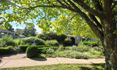
Soho Farmhouse is just about managing to maintain some green grass, despite being surrounded by thoroughly yellowed fields
In a social media post, DeGeneres joked her lawnmowing skills were ‘not great’, and said she and wife De Rossi would use sheep instead to keep the grass in check
George Clooney and his wife Amal evacuated their luxury French estate after a fast-moving wildfire raced towards their home this week (Pictured in France in May)
It is the marital home of Hollywood’s George Clooney and his high-flying international human rights lawyer wife Amal.
The couple are thought to have spent millions on a major renovation project after purchasing the property in 2014.
And despite its idyllic location, it has not all been plain sailing since.
Its setting on the nearby riverbank means it is prone to flooding, which happened in 2024 when floodwater took over the majority of their garden.
Fortunately, the couple’s property is thought to have remained unaffected.
But it’s a different problem this summer, as large parts of the county haven’t seen any rain since a light shower on July 2.
Despite being surrounded by tall trees which offers some shade to the edges of their garden, the central grass has completely yellowed in scenes reflected across Britain’s back gardens.
But even with a local hosepipe ban from Thames Water, the Clooneys’ thick forestry has left them better off than some of their compatriots – in the UK at least.
The family faced having to evacuate their vineyard home in the south of France this week amid huge blazes, including one just nine miles from Bordeaux.
They have no idea whether their property there is still standing, it is reported. It is not known where the Clooneys are currently staying.
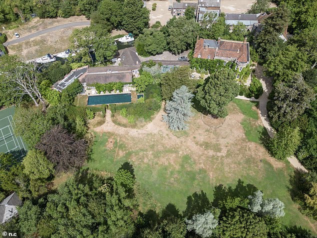
These extraordinary images of David Beckham’s 40-acre Oxfordshire estate show the shocking scale of the aridity that has hit so much of the UK
Now the only visible areas of green left appear to be the family’s five-a-side football pitch – which is thought to be made of artificial grass – a few more resilient trees and that cherished vegetable patch
The Beckhams have been on one long, almost-unbroken holiday this summer (Pictured on a break in Formentera this week)
Seven weeks after gushing to his followers about his beloved vegetable garden before jetting off to watch the World Cup, Sir David Beckham faced a stark reality upon his return, with images showing his parched, yellowed garden surrounded by barren fields in Oxfordshire.
The 40-acre Cotswolds estate has been abandoned by the Beckhams amid weeks of no rain, as they instead enjoy virtually non-stop holidays throughout the summer months.
From a yacht trip in the Mediterranean in May, to the World Cup in June and more recently Ibiza, the jet-setting family perhaps prefer to avert their eyes from their usually green and luscious lawns.
Now the only visible areas of green left appear to be the family’s five-a-side football pitch – which is thought to be made of artificial grass – a few more resilient trees and that cherished vegetable patch.
Their head gardener, Carly Holmes, is thought to have been paying special attention to the patch amid a Thames Water hosepipe ban affecting many Oxfordshire homes.
But the rest of their property is a grass wasteland, broken up only by patches of green around the Beckhams’ large pond.
Elsewhere in the Cotswolds, a farmhouse bought by former TV chat host Ellen DeGeneres and her wife Portia De Rossi is similarly beleaguered by the tough conditions, although the couple are having better luck than many.
Having purchased the property in 2024 following President Donald Trump’s election win, the couple initially looked to sell it following difficulties with flooding and a high-profile planning row over stables for De Rossi’s beloved horses.
Despite a drought having been declared in Oxfordshire, Ellen DeGeneres’ garden is an oasis of green amid its surrounding brown fields
Ellen DeGeneres and Portia De Rossi moved to the UK in 2024 following President Donald Trump’s election win
The River Windrush flooded much of the surrounding land, and the pair even briefly moved to a new property in 2025.
But the couple are now set to remain in their first UK home for the ‘long term’ after claiming victory in the planning battle.
Despite a drought having been declared in Oxfordshire, DeGeneres’ garden is an oasis of green amid its surrounding brown fields.
The couple previously shared their struggles with maintaining it, with a viral video of DeGeneres struggling to use a sit-on lawnmower.
In a social media post, she joked her lawnmowing skills are ‘not great’, and said she and wife De Rossi would use sheep instead to keep the grass in check.
Regardless of the couple’s secret, they are clearly doing something right as their garden stands out amongst an otherwise brown landscape.
They are not the only success story either – Soho Farmhouse is also just about managing to maintain some green grass, despite being surrounded by thoroughly yellowed fields.
It is home to an elite private members’ club beloved by A-listers including the Beckhams and Maya Jama, and also hosted Meghan Markle’s hen party.
The Chipping Norton venue has hosted stunning dinners, galas and holidays for the rich and famous, with on-site accommodation, a health club and plenty of sports facilities.
Images show that large parts of its grass are beginning to yellow, but it’s certainly faring better than much of the land around it.
Green-fingered homeowners are struggling across Britain following both May and June breaking Met Office monthly temperature records, with 35.1C recorded at Kew Gardens on May 26 and 38C recorded at Lingwood, Norfolk on June 26.
With much of England and the whole of Wales now officially in drought, forecasters are warning that current forecasts ‘do not favour the widespread, sustained rainfall’ needed to make up the shortfall caused by recent dry conditions.
Natural Resources Wales (NRW) extended its drought declaration – which was declared for North Wales and the Upper Severn last week – to cover the whole of the country, after very little rainfall and sustained high temperatures.
Wales has received just eight per cent of its long-term average rainfall for July, and the country is on course to have its driest July since records began 190 years ago, NRW said.
Met Office chief meteorologist Will Lang said: ‘While there is always the potential for periods of rain during the remainder of the summer, current forecasts do not favour the widespread, sustained rainfall that would be needed to make a significant difference to rainfall deficits that have built up over recent months.
Soho Farmhouse is home to an elite private members’ club beloved by A-listers including the Beckhams and Maya Jama, and also hosted Meghan Markle’s hen party
Even the greens at Buckingham Palace are suffering in the heat, turning almost entirely brown
‘As we move through August, there remains a tendency towards drier than average conditions, particularly in southern and eastern areas.
‘Meaningful recovery from prolonged dry conditions often relies on more frequent and widespread rainfall during the autumn months, when weather patterns typically become more changeable.’
The dry weather is also set to have an impact on food supply, with farming leaders warning they face ‘the worst harvest in years’ amid drought and successive heatwaves following a very wet winter.
Gavin Lane, president of the Country Land and Business Association that represents 28,000 farmers, said: ‘Farmers are telling us this is the worst harvest in years.
‘A sodden winter followed by drought has left wheat at half its usual height and some crops not worth harvesting.’
Parts of the country are suffering their third drought in five years, following 2025 and 2022.
And figures revealed this week that the UK is on track to record the highest number of excess heat deaths since records began.
An estimated 753 deaths were associated with the heatwave that ran from May 24-27, with a further 2,124 deaths linked to the heatwave between June 21 and 28.
The total of 2,877 deaths is almost double the 1,504 deaths linked to heatwaves in June to August last year.
Some 2,985 heat-associated deaths were observed across the five heatwaves of 2022, a year that had the highest temperature ever recorded in the UK, when 40.3C was reached in Coningsby in Lincolnshire on July 19.


You must be logged in to post a comment Login