Greater Manchester is basking in glorious, long-awaited sunshine on a chilly Valentine’s Day. Clear sunny skies have dominated so far today (February 14), on what one Met Office forecaster described as ‘the best day we’ve seen for some time’.
Advertisement
But clouds are expected to gather as the afternoon goes on, before wintry conditions return later tonight. A yellow weather warning for snow and ice comes into force at 9pm tonight and runs until 10am on Sunday morning.
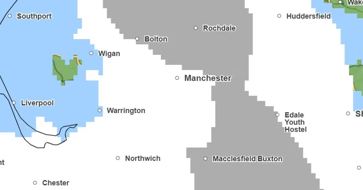
The Met Office says ‘snow, heavy at times, may cause some disruption to travel, especially over high ground during Saturday night and Sunday morning’. The warning covers north and east Manchester, plus Bolton, Bury, Oldham, Rochdale, Stockport, Tameside, and parts of Salford and Wigan boroughs.
Met Office maps show a band of rain, sleet and snow moving eastwards later tonight, first hitting Greater Manchester from around 10pm and covering the region within an hour. Maps from the Met Office suggest this will first land as rain and sleet, turning to snow by 11pm.
Advertisement
Thicker snow is expected in the early hours of the morning. At 1am, thicker snow is forecast around Bolton, Bury, Oldham, Rochdale and Tameside, while sleet and rain hits Wigan.
Wetter weather could hit Manchester, Salford, Trafford and Wigan from around 2.30am, with snow lingering on areas of higher ground after 3am. Rain should begin to clear at around the same time, before wintry conditions shift from the region by 5am.
A mostly dry morning is forecast in Greater Manchester on Sunday, but a band of heavy rain is expected to hit the region from 11.30am, moving eastwards until it clears the area by 1.30pm. Further spells of light rain and showers are forecast as the afternoon and evening goes on.
John Swinney has made reducing child poverty his number one priority as First Minister.
The SNP Government is set to miss a landmark target to reduce child poverty across Scotland by a “considerable margin”.
Advertisement
Then first minister Nicola Sturgeon unveiled ambitious plans in 2016 to reduce the level of child poverty to at most 10 per cent by 2030.
John Swinney has since made helping more kids out of poverty his “number one priority” since taking on the top job in Scottish politics.
But a report published today by the independentInstitute for Fiscal Studies (IFS) said that despite progress being made on the issue thanks to devolved policies – such as the introduction of the Scottish Child Payment – it was unlikely the target would be met.
The child poverty rate is currently around 21 per cent, compared to 28 per cent across the UK as a whole and 38 per cent in Greater London.
Advertisement
But experts said the lower level is largely due to housing costs in Scotland being substantially cheaper than those in the south of England, with Scots also more likely to live in a socially rented property.
The IFS also said there has never been a child poverty rate of 10 per cent in the UK, including in the 1960s when inequality in society was far lower than now.
Tom Wernham, senior research economist, said: “Scotland’s devolved benefit system is reducing income inequality and child poverty.
Advertisement
“Further increases in devolved benefits are the most direct way to continue to reduce child poverty.
“But the scale of benefit increases needed to achieve the very stretching 10 per cent child relative poverty target would cost billions of pounds per year and increase disincentives to work. Increases to employment and the wages of lower earners could, in principle, reduce poverty and boost Scottish Government revenues at the same time, but to deliver such increases at scale in practice would be very challenging.
“If the next Scottish Government also prioritises the living standards and life chances of children from lower-income families, a mix of benefit, labour market and public service policies will likely be needed.
“In the context of a constrained budget, it will also need to be clear eyed about what its key priorities are.”
Advertisement
Jackie Baillie, Scottish Labour deputy leader, said: “John Swinney and the SNP have always been more interested in setting targets than meeting them, but it is particularly shameful on an issue as serious as child poverty.
“A Scottish Labour government will work across government to tackle the root causes of poverty – fixing the basics and making sure our economy and our services work for Scottish families.
“Scottish Labour will fix the crisis in our NHS so people aren’t locked out of work through ill-health, build an education system that helps every child succeed, cut housing costs with the most ambitious housebuilding programme in the history of devolution, and deliver more well-paid jobs across our society.”
Jamie Greene, Scottish Lib Dems economy spokesman, said: “Despite the grand rhetoric from the SNP, they have left thousands of children in poverty.
Advertisement
“For the past nineteen years, the SNP have failed to use the powers they have had at their disposal to move the dial.
“Just like Nicola Sturgeon broke her promise to close the attainment gap, John Swinney has broken his promise to reduce child poverty. They simply cannot be trusted.”
Shirley-Anne Somerville, SNP candidate for Dunfermline, said: “Scotland has the lowest levels of child poverty on these islands – that’s thanks to SNP action in government and that’s exactly what you get from John Swinney’s strong leadership.
Advertisement
“John Swinney has made eradicating child poverty his number one mission and we are making good progress, despite complete failure from the Labour Party to get a grip of the cost of living crisis.
“Our game-changing Scottish Child Payment is unavailable anywhere else in the UK, and our plans for year round childcare for every child from nine months until the end of primary school will be transformative.
“The reality is though, our mission on child poverty is undermined by Westminster governments that have punished Scottish families time and again – only through a fresh start with independence can we break free of broken, Brexit Britain and build a fairer, wealthier, Scotland.”
To sign up to the Daily Record Politics newsletter, click here
President Donald Trump’s primetime address on the Iran war featured extraordinary claims about Venezuela, confusing war timelines, and promises about gas prices as fuel costs surge
President Donald Trump appeared for a primetime national address on Wednesday night to deliver an official update on his war with Israel against Iran, which has sent petrol prices soaring, resulted in the deaths of at least 13 American service members and sent the global economy into turmoil.
Advertisement
He and senior U.S. officials have for weeks given conflicting statements over when the costly war will conclude, what its objectives are and whether or not the administration will decide to deploy American boots on the ground in Iran. Trump himself has grown increasingly irritated with news coverage and has failed to find a way to explain why he started the war – or how he will end it – that resonates with the wider public.
But on the national stage, with prepared remarks before him, the president offered neither fresh information on the ongoing conflict nor clarity on how he will proceed in the days and weeks ahead. Instead, he appeared to improvise at length about Venezuela, supposed U.S. stockpiles of gas, the final words of slain U.S. troops and the superiority of American firepower even as he has demanded assistance from NATO allies.
Ensure our latest headlines always appear at the top of your Google Search by making us a Preferred Source. Click here to activate or add us as your Preferred Source in your Google search settings.
1. Trump claims U.S. troops ‘took’ Venezuela
Trump claimed on Wednesday that American troops did a “masterful job” in “taking the country of Venezuela,” a comment that follows weeks of him discussing “running” the South American nation while leveraging its political transition to benefit American oil companies. “I also want to thank our troops for the masterful job in taking the country of Venezuela in a matter of minutes,” Trump declared during his speech, referring to his unexpected nighttime military assault on Venezuela’s capital, Caracas, in January that led to numerous casualties and the capture of former President Nicolás Maduro, reports the Mirror US.
“That hit was quick, lethal, violent and respected by everyone all over the world,” he asserted.
Advertisement
However, in reality, Maduro’s capture faced severe backlash from both U.S. allies and adversaries, including at an emergency meeting of the U.N. Security Council on the day of his court appearance.
2. Trump claims Americans ‘have so much gas’ as prices skyrocket
Emphasising his perspective on the robustness of the U.S. economy under his leadership, which is facing unprecedented disapproval among Americans, Trump attempted to alleviate concerns about escalating petrol prices as the war continues.
Advertisement
Arguing that the U.S. has ample fuel reserves due to his “drill baby, drill” stance on domestic oil production, Trump stated that the nation produces more oil and gas than Saudi Arabia and Russia combined, according to The Associated Press.
The U.S. was the top oil producer globally in 2025, pumping more than 13 million barrels per day. Russia and Saudi Arabia ranked second and third worldwide, each producing more than 9.5 million barrels per day, as per the U.S. Energy Information Administration.
This week, US petrol prices climbed beyond an average of $4 per gallon for the first time since 2022, as the Iran conflict continues driving fuel costs upwards globally. The last occasion US motorists collectively paid this much at forecourts was nearly four years ago, following Russia’s invasion of Ukraine.
3. Trump adjusts war’s timeline to ‘two or three’ more weeks
Advertisement
Since the US and Israel initially struck Iran on 28 February, the president and his senior officials have provided inconsistent responses regarding the conflict’s duration.
Combat “will continue until all of our objectives are achieved,” Trump told reporters on 29 February. He subsequently suggested it would conclude in four, five or even six weeks. Now with the war approaching its sixth week, Trump continues wavering between declaring complete victory, suggesting he will soon be prepared to withdraw from the Middle East, and threatening to escalate it further.
On Wednesday, Trump again extended the deadline for the war, which the Centre for Strategic and International Studies estimates is costing the US approximately $891.4 million daily.
Advertisement
“We are on track to complete all of America’s military objectives shortly. We are going to hit them extremely hard over the next two to three weeks,” he stated. “We’re going to bring them back to the stone ages, where they belong.”
4. Trump urges Americans to consider the war as an investment in their future
“This is a true investment in your children’s and grandchildren’s future,” Trump stated. “The whole world is watching, and they can’t believe the power, strength and brilliance. They just can’t believe what they’re seeing!” However, U.S. allies abroad are scarcely impressed by America’s military capabilities, and appeals to join Trump’s conflict have been largely rebuffed.
Advertisement
Amidst soaring petrol prices, Washington has encountered widespread condemnation from European allies, including U.K. Prime Minister Sir Keir Starmer.
“It is increasingly clear that as the world continues down this volatile path, our long-term national interest requires closer partnership with our allies in Europe,” Starmer remarked at a Downing Street press conference on Wednesday after declining to join the war.
Drawing closer to Europe represents a clear indication of British foreign policy moving away from the so-called ‘special relationship.’
5. Trump’s assertions about state of conflict contradict reality
Advertisement
Trump on Wednesday described Iranian leadership as a “new regime,” despite the current Supreme Leader, Mojtaba Khamenei, being the successor of the slain Ali Khamenei. He also maintained that the war is almost finished, before suggesting it could continue for up to three more weeks. Tehran has stated there have been no substantial negotiations with the US, and Trump has repeatedly threatened to further intensify the war.
Democrats condemned the address as “incoherent” and as doing little to address “the most basic questions of the American people,” according to statements from two Democratic lawmakers issued on Wednesday.
Sen. Mark Warner observed that Trump owed Americans more clarity about a conflict that has pushed up prices on petrol “alongside rising prices for diesel, fertiliser, aluminium, and other essentials, with consequences that will continue to ripple through the economy for a long time to come.”
Advertisement
Meanwhile, Sen. Chris Murphy issued a statement declaring the “speech was grounded in a reality that only exists in Donald Trump’s mind.” Murphy continued to note that “no one in America, after listening to that speech, knows whether we are escalating or deescalating.”
Follow our live blog for the latest updates by clicking here.
Ben McCulloch – son of Scottish gangland boss Brian McCulloch – was filmed partying with other out-of-control prisoners.
04:30, 02 Apr 2026
Mark McGivern at HMP Addiewell as families demand action over prison cell parties
A grieving family have demanded a crackdown on killers trolling from behind bars after being sickened by jail TikTok videos.
The mother and sisters of slain Stephen Quigley are pleading for a new law to hammer gloating criminals after the Record revealed a series of videos filmed inside crisis-hit Addiewell nick.
Advertisement
Katie Quigley has told of her pain as she watched killer Ben McCulloch – son of Scottish gangland boss Brian McCulloch – party with other out-of-control prisoners in a video that was put on TikTok.
Along with daughters Catrina, 33, and Margaret, 37, she is pleading for a crackdown on the toxic masculinity and macho lawlessness that they claim the Scottish Prison Service seems unable to keep under control.
The recent TikTok video from McCulloch – featuring violence, bullying and drugs – glorified the 24-hour party life he and pals, stripped to the waist, claim to be living the high life at HMP Addiewell, in West Lothian.
That video followed an earlier shameful Instagram post that emerged from HMP Shotts, where bully McCulloch, 31, and murderer pal Ross Fisher were photographed. A caption on the post openly mocked the men they killed – saying “They’re deed and we’re no – hahah.”
Advertisement
It is understood that McCulloch has been prosecuted for abuse of smuggled mobile phones – and received “concurrent” sentences, which added zero time to his sentence.
Katie Quigley, whose demand for a clampdown is being backed by MSP Paul O’Kane, said: “I cannot put into words just how hurtful it was to see this man’s face on a photo, with a caption on it referring to the death of my son and the fact his killer is doing ‘easy time’.
“Ben McCulloch killed my boy, who was meant to be his best friend. His lawyer told the court that he was full or remorse but he has not one shred of remorse. If he did, how could he be posting videos about having 24 hour parties?
Advertisement
“And what punishment has he received? We were told by the SPS he was given concurrent sentences, which is no punishment and no deterrent at all.”
Katie, from Neilston, Renfrewshire, said she would like Scottish ministers to pass a specific law that ensures extra time behind bars for any prisoner who uses a mobile phone to create video content that cause torment for the family of victims.
She said: “I had to identify my dead son and that awful day will stay with me for as long as I am alive. Is it too much to ask for prisons to stop these gangsters reminding the families of all the people they have killed or victimised that they are running the jails?
“I really does look from the videos that things are out of control. How can you have a cell that is full of drunk men having a party inside, taking videos, somehow getting an internet connection to post all their horrible footage?
Advertisement
“It just breaks my heart to think of the lack of remorse that is evident in every one of those videos.”
Stephen’s sister Catrina, 33, said the family has been forced to endure a “life sentence” after their loss in 2021.
McCulloch, now 31, was jailed for nine-and-a-half years for knifing Stephen before leaving him to die on a pavement outside Paisley’s Royal Alexandra Hospital in Paisley.
Advertisement
The High Court in Glasgow heard that Stephen would have lived if McCulloch had taken him to A and E.
Catrina said: “Stephen was best mates with Ben and they were on good terms before he killed him. His lawyer bleated in court about his remorse but his behaviour in prison is a disgrace.
“We need to stop the flood of phones into prisons and we need to give proper punishments to those who are torturing families like ours from inside jails.
“As it stands there is no deterrent. Vulnerable young men are looking at these prisoners like role models and thinking they can get in with the mob while doing easy time in jail themselves.”
Advertisement
The Daily Record told recently how Ben McCulloch and other cons at HMP Addiewell were raving in their cells, posting videos that appeared to show men out of their heads on drugs and prison hooch.
The apparent lads party videos were captions with claim that prison time is easy and a 24 hour party.
Further videos emerged from top security HMP Shotts and Barlinnie, where a growing craze appears to be emerging for young prisoners to brag about the fun times they are enjoying behind bars.
Advertisement
And the Quigley family had previously been outraged at the Instagarm content that featured McCulloch with killer Ross Fisher, 34 – who was one of a gang of four who were jailed for the gangland murder of Kenny Reilly in Maryhill, Glasgow, in 2018.
Ben McCulloch’s dad Brian, now 55, was a ringleader in a multi-million-pound drug plot that was cracked after a police surveillance sting.
In 2009 the High Court in Glasgow heard how McCulloch plotted with other gangsters.
Due to the bugging of McCulloch’s BMW, police raided properties in Glasgow, Paisley and Clydebank, recovering drugs with a street value of £9million, along with firearms and almost £500,000 in cash.
A ring of steel was thrown around the High Court in Glasgow ahead of their sentencing hearing, amid fears of an escape bid from the gang.
Officers from the tactical firearms unit, armed with sub-machine guns, stalked the court building while the police helicopter circled above.
The police operation, codenamed Operation Lockdown, ran from August 2007 to February 2009, involved up to 100 officers on any given day and cost an estimated £2.7million. Brian McCulloch got 10 years for his leading role in the gang.
Advertisement
Labour MSP Paul O’Kane said Scotland needs an overhaul of the way it deals with the taunting that comes from inside prisons on illicit videos.
He claimed that his plea for action on the Quigleys’ case had been fobbed off by justice minister Angela Constance when he raised it in a letter.
O’Kane said: “I have been supporting the Quigley family for some time and I know how shocked the whole community in Neilston was at Stephen’s killing. It is horrific that the family’s pain is being compounded by the action of those found guilty in prison.”
Advertisement
“It is clear that the SNP Government take a soft touch approach and have not acted to get a grip of the situation within our prisons – with mobile phones being smuggled in and so called parties taking place in prison wings which are being filmed for social media”
“My pleas to Angela Constance have fallen on deaf ears and this is heartbreaking for the family”
“We clearly need a new Government in Scotland to take decisive action on securing our prison estate and looking at the whole issue of punishments for taunting victims of crime from behind bars.”
A Scottish Prison Service spokesperson said: “We understand the lasting impact this kind of offending has on families and the significant distress such videos can cause.
“Our staff work hard to keep prisons safe and secure, using all available technology and intelligence to prevent illicit items, including mobile phones, entering our establishments.
“While we do not comment on individuals, we continue to work with Police Scotland, and other partners, to take action against those who attempt to breach our security.”
The Scottish Government is currently restricted in statements that might be made on future policy.
Advertisement
A previous statement stated: “This is an operational matter for the SPS which uses a range of technology and intelligence to stop illicit items reaching our prisons.
“As previously announced in 2026-2027, we are investing just over £1billion in our prisons to support frontline staff.”
Get more Daily Record exclusives by signing up for free to Google’s preferred sources. Click HERE.
He wrote: “All of those countries that can’t get jet fuel because of the Strait of Hormuz, like the United Kingdom, which refused to get involved in the decapitation of Iran, I have a suggestion for you: Number 1, buy from the US, we have plenty, and Number 2, build up some delayed courage, go to the Strait, and just TAKE IT.
Dr Punam Krishan has spoken about the ‘aftermath’ of suffering from cancer
Howard Lloyd Regional content editor
04:59, 02 Apr 2026
A GP has highlighted a side-effect of cancer that she says ‘nobody tells you about’. Macmillan Cancer Support estimates that around 3.5 million people in the UK are living with cancer.
This equates to one person being diagnosed every 75 seconds in the country, and 168,000 individuals dying from it each year – that’s 460 people daily. The combination of an ageing population, improved diagnostics and increased public awareness means the number of recorded cases is expected to rise annually.
Advertisement
Dr Punam Krishan is one of these individuals. The Glasgow-based GP, known for her appearances on daytime television and informative posts on social media, revealed in January 2026 that she had been diagnosed with breast cancer.
Thankfully, her recovery is going well. However, after seeing a patient at her practice, she was reminded of something she believes all cancer patients should be aware of.
She stated: “I wanted to share something with you, something that nobody really tells you about cancer. And something that I realised I shared in common with a patient today and it’s the bit that comes after. It’s the health anxiety, which is a whole new kind of anxiety by the way.
Content cannot be displayed without consent
“Now as most of you know, I’ve not long finished treatment for breast cancer myself and I am still very much healing, still taking it day by day. And physically, I’m getting there but mentally it’s been a very different kind of healing. I mean, even just yesterday to give you an example, I was in the car and I felt a wee pain in my arm and within minutes my mind had spiralled to, ‘what if it’s back?’ and I found myself calling my husband and then my mum and my best friend just needing that bit of reassurance.
Advertisement
“And then I had to really, really catch myself, take a breath, slow the heck down and go back to the little mantras that I have learned and the tools that my therapist has given me over this time just to bring myself back to the present moment, control the controllables and the pain settled within a few minutes. It was nothing serious but that feeling, that jump from zero to a hundred, anyone that knows and has been there, it is so real. And in medicine, of course, we call this health anxiety, where your brain becomes hyper-alert to every single sensation and it starts to scan for danger.
“But after something serious like cancer, everything feels different. And I sometimes think of it as an aftermath anxiety. Honestly, it feels like the mother of all anxieties because your brain isn’t imagining danger, it’s remembering it and your body has been through something so real and your mind is just trying to protect you. Just sometimes it overdoes it.
“So today then, in clinic, I saw this clearly again in front of me, a patient who has also had cancer and she was telling me she just can’t switch off the worry sometimes. She’s barely sleeping some days, her mind keeps going back to, ‘what if it’s still there?’ and she said that she almost felt like I wouldn’t understand and was worried about sharing this because people around her keep telling her, ‘oh, it’s nothing’.
“But sitting here with her I was thinking, ‘I see you, I get it, because I’m in that space too’ and I shared that with her and it’s not nothing. This is a real and valid feeling and it just made me realise how little we talk about this part. The fear of recurrence, the hyper-vigilance, that loss of trust in your own body. And we’re not really taught it, not as patients and if I’m really honest, not even as doctors. I wasn’t taught this. I sadly had to learn this by living through it.
Advertisement
“So if you’ve ever felt that shift from calm to panic or find yourself checking, worrying, needing reassurance, you are not imagining it and you are not over-reacting. Your mind, it is responding to something that your body has genuinely been through and I don’t think that that just switches off overnight.
“Oh my goodness, I wish it did, but with time, with support and a lot of self-compassion, it should start to soften as you begin to find your new normal. So if you are in this space just now, just know that you are not alone. And if you are supporting someone more importantly that is going through this, please don’t minimise what they are feeling. Give them a big hug, give them the space to share. This is part of their healing journey as well.”
Why are cancer cases increasing?
Cancer cases are on the rise – and projections suggest this trend will continue for the foreseeable future. An ageing population combined with improved diagnostics and greater public awareness partly explains this – but additional factors are also at play.
Firstly, the UK’s population is growing, which means there are more individuals who can develop the disease. While older people remain more vulnerable to cancer, certain types are appearing in growing numbers of younger people – particularly bowel cancer.
Advertisement
Advances in cancer treatment mean more people are surviving the disease. The number of individuals living with cancer in the UK has risen from nearly 3 million in 2020 to almost 3.5 million in 2025.
On paper, the numbers look astonishing. The annual rate of inflation in Argentina has plummeted from 211% in 2023 to 31.5% by the end of 2025.
President Javier Milei is taking plenty of credit for the drop. And he spent some time on Wall Street last month, pitching his “chainsaw” approach to public spending as a triumph against inflation.
For the drop in inflation is certainly not a victory for Argentine productivity. It’s a byproduct of a deliberate and engineered collapse in people’s wages.
Advertisement
Milei hasn’t fixed the engine of Argentina’s economy, he has simply turned it off. Since he took office in 2023, the country’s manufacturing output has dropped dramatically, with over 2,000 businesses shutting down and 73,000 jobs lost.
These aren’t just dry statistics. Real wages have been crushed so hard that demand for Argentine goods has evaporated. If a manufacturer is only using a third of its machinery because nobody can afford their goods, they lose their ability to put up prices, and inflation rates stop rising.
By drastically reducing demand, Milei has not solved the inflation puzzle. He has simply removed some of the pieces, by making the population too poor to participate in the Argentine economy.
Advertisement
On top of this, the fear of mass unemployment means workers have no choice but to accept an ever smaller share of the nation’s economic pie. Again, low wages serve to prevent the upward spiral of prices.
So the supposed victory over inflation is actually the institutionalisation of lower wages and a lower standard of living for most people.
A recently passed law (officially named “labour modernisation”) reinforces this new reality. It has effectively increased many workers’ hours and reduced their protections, making labour both cheaper and more disposable.
The new legislation has been criticised as a return to working practices of the 19th century. Far from modernising work, it is about normalising a lower wage share of GDP and ensuring that the shrinking slice of the national income for the Argentine worker isn’t just a temporary emergency, but a permanent feature of the model.
Advertisement
And while the government highlights 4% GDP growth forecasts for 2026, that growth is focused in sectors like agriculture, mining and lithium, which create very few jobs. For the average urban worker the economy hasn’t recovered – it has simply bottomed out at a new, lower standard of living.
Wages down, inflation down
That doesn’t mean that the drop in inflation counts for nothing. There has been a genuine sense of relief after the triple-digit chaos of 2023.
The simple ability to shop at a supermarket without the price of goods changing dramatically in days will mark a deep psychological shift for many Argentinians.
But that shift is not based on solid ground. Inflation hasn’t been tamed by a more efficient economy – it has been starved into submission.
Advertisement
Yet remarkably, Milei’s “miracle” is already being packaged for export. From the radical fiscal cuts proposed by Trump in the US to the nationalist platforms of Orbán in Hungary and the Vox party in Spain, Milei and his model are being touted as a blueprint for other economies struggling with inflation.
Protests in Buenos Aires against new labour laws, February 2026. EPA/Juan Ignacio Roncoroni
But what looks like a triumph to some is, in reality, a deepening social crisis. Milei’s Argentina is not a blueprint to be followed. It is a warning of what happens when the cure for inflation is more lethal than the disease itself.
For this level of wage suppression is a stark reminder of Argentina’s economic crisis of 2001, a period of total state failure, sovereign default, bank freezes and 20% unemployment that left a permanent scar on the national psyche.
To have surpassed that level of wage suppression today is a damning indictment of Milei’s approach. But while 2001 was a sudden collapse of a monetary system, the 2026 reality is a slow, institutionalised asphyxiation.
Advertisement
The question for the coming years is how such a model can possibly be sustained. Milei has left the country with no economic levers to pull for a genuine recovery.
With negative net reserves, a domestic market in ruins, and multi-billion dollar IMF and private debts hanging over the country, the government’s path is now dictated entirely by a desperate need for dollars that turns every domestic policy into a plea for foreign capital.
This has created an economic vacuum in which there is no credit for small businesses, no surplus for public investment and no consumer demand to entice private capital back into the real economy.
That is why the administration’s pitch to New York investors in March was essentially a desperate plea for capital to fill this void. But Wall Street is not generally in the business of building factories or creating jobs in Argentina.
Advertisement
If anything, its investors will be looking for easy short-term profits in a newly deregulated market. And what emerges then is an economically divided Argentina. On one side of this will be a thriving enclave of mining and agribusiness designed for the global market, and on the other, a vast urban industrial wasteland where millions of Argentinians struggle desperately to make ends meet.
A 32-year-old man was sent to prison for more than four years after pleading guilty to causing death by dangerous driving
The family of a woman killed in a crash on the Cambridgeshire border has paid tribute to her. Last week, Mantas Kudrevicius was sentenced to four years and six months in prison after a tragic crash in 2024.
Advertisement
While driving towards Spalding on the A16 near Cowbit, Lincolnshire on August 30, 2024, Kudrevicius crossed into the opposite carriageway and crashed into a Renault Twingo. In the Renault was 28-year-old Shinead Francis.
Shinead died at the scene of the crash. Following Kudrevicius’s conviction, Shinead’s family has paid tribute to her.
In a statement, her family said: “On August 30, 2024 our lives changed forever, when our beautiful Shinead was taken from us in a collision. Her loss has left a vast emptiness in all of our lives.
“Shinead was one of those people who brought joy and happiness to all who met her. Whenever she walked into the room, her smile and zest for life lit up the room. In fact, that joy was just infectious to all around her.”
Advertisement
Shinead was described as someone who was “always there for others” and a “confidant”. Her family added: “[She was] kind to others in their hour of need, huge hearted and a gentle soul, providing love to all around her. Her life had meaning and value.
“Her future was full of expectation and joy. She had plans to settle down and couldn’t wait for the day that she became a mother herself.
“She has achieved so much in her 28 years and had so much more to give. She was immensely proud of obtaining her HGV licence and referred to herself as a ‘Mother Trucker’.
“Her humour and sage advice supported all around her, guiding both friends and family through those dark periods that we must now all bear alone. We will miss her dancing, giggling, positivity, her physical presence and her sense of fun.
Advertisement
“She had a love of penguins and had a collection of cuddly ones in her room – Christmas saw her place at the table taken by one of her cuddly penguins. When her grandmother required help at home, Shinead stepped in to provide that help.
“She did the shopping, tended the house and the garden and talked about her future plans to her grandmother. We will never forget our beautiful Shinead, the one who brought a breath of fresh air and a ray of sunshine to whomever she met.
“Everywhere is now a duller, less colourful place without her and the world has lost one of those who was an embodiment of all that was good. Rest peacefully Shinead, you remain deep inside our hearts and we will love you forever. Until we may all meet again.”
The Kiltonga Nature Reserve is to be restored as part of the plan
A controversial plan for a new housing estate beside the famous Duck Pond in Newtownards has been approved, after being deferred for a year amidst questions about residential plans on an industrial site.
Advertisement
Elected members at the Ards and North Down Council March Planning Committee meeting this week (March 31) approved an application by Jona Developments for a residential development comprising 29 dwellings, that is 25 detached and four semidetached, at lands to the northwest of Kiltonga Industrial Estate, close to Belfast Road Newtownards. The site is close to the cherished Kiltonga Nature Reserve, known locally as the Duck Pond.
A year ago the plan was deferred after councillors questioned if local developers were engaged in a “ploy” to build residential housing estates on industrial zoned lands by introducing plans for nursing homes which would be then quickly dropped.
The matter was deferred for an extensive period for legal advice on the concerns raised by members including a former age-related condition and the implications of a former Planning Appeals Commission decision, as well as further information from Environmental Health on noise and smell issues that had been reported by residents.
Officers recommended the application for approval. In terms of letters of objection, the council received four, from three addresses. Objectors raised issues around limited parking, increase in traffic, flood risk, threats to flora and fauna and one said there was a threat to mental health of locals who would have green space taken away.
The Planning report states: “Biodiversity has been considered in the Ecological Survey which was submitted and reviewed by the Natural Environment Division. NED offered no objections to the proposal subject to the submission of a final Construction Environmental Management Plan and a Badger Mitigation Plan.
“While the application site currently appears as a green space to local residents, it is zoned for industry and is located within the Newtownards settlement limit where there is a presumption in favour of development on the site. “
Advertisement
It adds: “DfI Rivers offered no objection to the proposal, subject to a condition relating to the submission of a final drainage assessment.”
It states: “A parking schedule has been provided which indicates that the in-curtilage parking provision along with additional spaces for visitors can all be provided within the application site. The parking provision is in accordance with the recommended guidelines as set out in the Parking Standards document. DfI Roads has considered the proposal and offers no objection to the proposal.”
There is an extensive history of planning applications at the site. In 2012 there was a successful application by Kiltonga Care Services for the erection of a residential nursing home and in 2019 there was a successful application by Will Hollinger Beltraine Developments Ltd at the site for 20 retirement bungalows.
Also in 2019 a condition on the 20 retirement bungalows – that none of the dwellings should be occupied until the adjacent residential nursing home was constructed and operational – was deleted after an appeal. None of these works were completed.
Advertisement
A Planning Officer told the Committee on Wednesday: “Whilst the proposal is contrary to the (zoning) plan, the planning history represents a significant material consideration.”
She said: “The proposed plan adopts a landscape-led approach, including generous green buffers, and structured landscaping with a defined meadow area. There will be a spacious, low-density layout, with dwellings arranged around the existing pond, which will be retained and enhanced as part of the overall scheme.”
She added: “The principle of residential use has already been established on this site, and relevant planning history includes an approved and extant nursing home, with a certificate of lawfulness confirming commencement, approval for 20 retirement dwellings with commencement also certified.”
She said: “The pond is an established feature on this site and its inclusion is not considered to materially increase the risk beyond that typically associated with residential developments located near open water. In addition, the pond is not unique to this residential scheme.
Advertisement
“The proposal is therefore considered acceptable from a safety perspective.” She said the zoning “was no longer variable for industrial use.”
She said: “Market evidence indicates that the proposed housing mix better reflects local housing needs, with the site being less suited to an age restricted scheme, given the limited access to services and facilities. Environmental Health has reassessed the application and raises no objection on noise or odour grounds subject to mitigations secured through conditions.
“The proposal secures ecological enhancement, including pond restoration to support the local population of legally protected species.”
He continued: “I have a suggestion. Number one, buy oil from the United States of America. We have plenty. We have so much, and number two, build up some delayed courage. Should have done it before. Should have done it with us as we asked, go to the strait and just take it, protect it, use it for yourselves.
WASHINGTON (AP) — Homeland Security Secretary Markwayne Mullin on Wednesday rescinded a rule that DHS expenditures over $100,000 be personally approved by his office, ending a widely criticized policy implemented by his predecessor Kristi Noem that critics said put a particular burden on the Federal Emergency Management Agency ’s work aiding disaster response and recovery.
The decision marks the first major action by the new Homeland Security leader, sworn in last week, to change a policy implemented by Noem, whom President Donald Trump fired in March.
Mullin’s move is expected to ease a spending bottleneck that lawmakers and states said delayed disaster response and recovery funds, though those impacts are unlikely to be widely felt until after the end of the DHS shutdown, now in its 47th day.
A DHS spokesperson confirmed that Mullin rescinded the rule Wednesday, telling The Associated Press the secretary “re-evaluated the contract processes to make sure DHS is serving the American taxpayer efficiently.” CBS News first reported Mullin’s decision.
Advertisement
The spokesperson said Mullin’s action will streamline the contracting process and allocate aid more efficiently.
The International Association of Emergency Managers praised Mullin’s decision. “We appreciate Secretary Mullin’s common-sense approach to this matter, and we look forward to working with him,” said Josh Morton, president of IAEM-USA.
Noem issued a directive last June requiring that she personally approve any Department of Homeland Security expenditure over $100,000. Critics said the rule undermined FEMA in particular, an agency that routinely issues contracts and reimbursements well over that amount in its work preparing for and responding to natural and manmade disasters across the U.S.
The policy created “an untenable situation for emergency managers,” Morton said, and a bottleneck that also hindered mitigation and preparedness programs, “putting Americans at increased risk from disasters.”
Advertisement
A recently released report by Democratic members of the Senate Homeland Security and Governmental Affairs Committee found the approval rule had delayed at least 1,000 FEMA contracts, grants or disaster reimbursements by September.
The policy came under scrutiny after news reports linked it to unstaffed call centers and delays deploying FEMA Urban Search and Rescue teams to Texas during deadly floods last July, and brought sharp rebuke from some state officials and lawmakers, especially Republican Sen. Thom Tillis of North Carolina, whose state is still recovering from devastation wrought by Hurricane Helene in 2024.
“You’ve failed at FEMA,” Tillis told Noem at a Senate hearing two days before she was fired.
About $2.2 billion in recovery and mitigation dollars were in the DHS approval queue Wednesday, according to FEMA data seen by the AP.
Advertisement
“It’s got a great mission, and I think people at FEMA want to do their job,” Mullin told lawmakers at his March confirmation hearing, sparking cautious hope that he would ease the tumult experienced at the agency under Noem.
Mullin said he would keep the agency ”adequately staffed” after it lost over 2,400 employees last year, and said he was already considering nominees for a permanent FEMA administrator, which the agency still lacks.
Trump has repeatedly floated the idea of eliminating FEMA, saying as recently as Tuesday that the agency is “very expensive and it really doesn’t get the job done.”
Michael Coen, FEMA chief of staff during the Obama and Biden administrations, said, “Hopefully this a step toward transparency and stability between FEMA and states.”
Lifting the spending approval rule will not necessarily mean a rapid flow of FEMA reimbursements to states, tribes and territories, as the agency is still impacted by the DHS fund impasse, now the longest government shutdown in U.S. history.
While FEMA disaster response and recovery activities are paid out of a non-lapsing Disaster Relief Fund, that money is running low, a FEMA official warned lawmakers in a House hearing last week, with about $3.6 billion remaining. The DHS appropriations bill would add just over $26 billion to the fund.
A previous version of this story misstated that the DHS shutdown was in its 46th day, not its 47th, and that the Senate hearing where Tillis rebuked Noem took place one day before her firing, not two.


You must be logged in to post a comment Login