

Business
(VIDEO) Severe Overnight Storms Bring Heavy Rain, Strong Winds and Tornado Warning to Kansas City Metro

KANSAS CITY, Mo. — Powerful overnight storms swept through the Kansas City metropolitan area and surrounding regions early Monday, June 1, 2026, unleashing heavy rainfall, strong winds and at least one tornado warning as a line of severe thunderstorms moved across the region.
A severe thunderstorm watch covering much of the Kansas City area expired at 3:45 a.m., though a separate watch remained in effect until 5 a.m. for Cooper, Howard and Saline counties in Missouri. Multiple severe thunderstorm warnings were issued throughout the night, with the strongest activity occurring around 1:30 a.m. when a tornado warning was briefly active for portions of Clay and Jackson counties, including parts of Independence and Raytown.
The storms produced localized heavy rainfall that led to flash flood warnings in Clay, Platte and Wyandotte counties. Residents reported frequent lightning, gusty winds and periods of intense downpours, though impacts varied significantly across neighborhoods, with some areas experiencing minimal precipitation while others saw significant accumulations.
First Alert Meteorologist Pete Grigsby noted that warm temperatures, sunshine and increasing atmospheric instability fueled storm development through the evening and overnight hours. Storms initially formed southwest of Kansas City before tracking east-northeast, eventually organizing into a cluster or line of thunderstorms that persisted into the early morning.
The primary threats from the stronger cells included damaging wind gusts and large hail. While the tornado threat remained relatively low overall, the brief tornado warning prompted residents in affected areas to take shelter as a precautionary measure.
Storm Timeline and Warnings
The severe weather unfolded over several hours with multiple rounds of warnings:
- At 12:08 a.m., a severe thunderstorm warning was issued for Jackson, Clay, Leavenworth, Platte and Wyandotte counties until 1 a.m.
- Around 1:12 a.m., the strongest storm moved through the Northland, with the warning extended for parts of Clay, Platte, Jackson and Wyandotte counties.
- At 1:38 a.m., a tornado warning was issued for Clay and Jackson counties until 2:15 a.m., prompting immediate sheltering in the Kansas City metro.
- By 1:53 a.m., the tornado warning was canceled, though severe thunderstorm warnings continued for several counties.
- Additional warnings followed for Chariton, Linn, Macon and Randolph counties into the pre-dawn hours.
By 3:45 a.m., most immediate threats had passed, though isolated strong storms lingered in outlying areas.
Monday Forecast and Week Ahead
Following the overnight activity, Monday is expected to be much quieter across the region. Skies should gradually clear, with temperatures moderating into the comfortable range under mostly dry conditions. The remainder of the workweek looks predominantly dry before rain chances return late Friday and continue into the weekend.
Residents are advised to remain cautious of lingering localized flooding in low-lying areas and to exercise care when traveling on potentially slick roads this morning. Minor wind damage and small hail were reported in some locations, though widespread significant impacts appear limited.
Impact on the Community
The storms arrived as many residents were sleeping, with some awakened by thunder and strong winds. Emergency services received scattered reports of downed tree limbs and minor street flooding, but no major structural damage or injuries have been reported as of early Monday morning.
Local utilities reported a small number of power outages, primarily in rural areas, with crews working to restore service. Kansas City area airports experienced minor delays due to the weather but maintained operations throughout the night.
The National Weather Service continues monitoring the region for any additional development, though the overall pattern for the next several days favors more stable conditions. Residents are encouraged to stay informed through official channels and local media for any updates.
Broader Weather Patterns
The overnight storms fit into a pattern of increasing severe weather potential across the central United States as spring transitions into summer. Warm, moist air from the Gulf combined with atmospheric instability created favorable conditions for thunderstorm development.
Such events highlight the importance of having multiple ways to receive weather alerts, including NOAA weather radios, smartphone applications and local television coverage. The quick issuance and cancellation of warnings during the overnight hours demonstrated the dynamic nature of severe weather forecasting.
As the Kansas City metro moves into June, attention will shift toward typical early summer patterns of scattered afternoon thunderstorms and warmer temperatures. The region has experienced a relatively active severe weather season so far in 2026, with several significant events already recorded.
Safety Reminders for Residents
Local emergency management officials remind residents to review their severe weather safety plans. Key recommendations include having a designated safe space away from windows during tornado warnings and avoiding travel through flooded roadways.
For those dealing with any storm-related damage, insurance documentation and proper cleanup procedures are advised. The American Red Cross and local community organizations stand ready to assist anyone affected by the overnight weather.
Looking ahead, the transition to drier conditions this week should provide relief and allow for normal outdoor activities. However, the return of rain chances late in the week serves as a reminder that summer weather patterns can change rapidly.
The National Weather Service will continue providing regular updates as the week progresses. Residents are encouraged to download weather applications, sign up for local alert systems and stay aware of changing conditions, particularly during the afternoon and evening hours when thunderstorm development is most common.
Monday’s quieter weather offers a welcome break after the active overnight period. With the severe weather threat diminishing, focus shifts to recovery efforts in impacted areas and preparation for the warmer days ahead.


The film’s opening is a return to form for Disney and Pixar after facing notable challenges in recent years.

BNP Paribas: The Market Is Underestimating Valuation Risk

US military says it struck vessel in Caribbean, killing two


Global business leaders back faster electrification shift

Gold rebounds as US-Iran talks progress; Fed outlook worries cap gains

Mineral Resources chair Malcolm Bundey is preferencing an internal candidate to succeed founder Chris Ellison after completing a global search for his replacement.


China targets US rare earth and other firms with export controls

Venice may hike visitor entry fee to €50 to curb overtourism
Venice’s new mayor, Simone Venturini, proposes a significant hike in the city’s controversial entrance fee, potentially reaching €50 on peak days. This move aims to curb overtourism by discouraging day-trippers and generating funds for the city’s upkeep. The fee, already in place since 2024, could see a substantial increase, pending government approval, as Venice seeks to balance resident needs with tourist influx.

Iran touts progress in US peace talks; negotiations set to continue


Metcash FY26 presentation: diversification offsets tobacco decline

Toy Story 5 sees franchise's biggest ever opening weekend

Christian Lundgaard overcomes early collision to win XPEL Grand Prix

Anthropic’s Mythos mess just keeps getting more complicated


![LISA - 'MONEY' Dance Practice [Mirrored]](https://wordupnews.com/wp-content/uploads/2026/02/1770259125_maxresdefault-80x80.jpg)

-
 Crypto World7 days ago
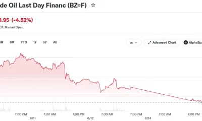
Crude Oil Plunges Over 4% as US-Iran Agreement Reopens Hormuz Strait
-

 Fashion2 days ago
Weekend Open Thread: Miami – Corporette.com
-

 Tech5 days ago
The Adder At The Heart Of Intel’s 8087 FPU
-
 Business2 days ago
Wall Street Week Ahead: Investors see Micron earnings as pulse check of AI rally momentum
-

 Crypto World2 days ago
HIVE shares jump as $220M AI deal speeds Bitcoin mining pivot
-

 Sports3 days ago
FIFA World Cup 2026: Canada beat 9-men Qatar 6-0 to register first ever win | FIFA World Cup 2026
-

 Business1 day ago
MHP SE 2026 Q1 – Results – Earnings Call Presentation (OTCMKTS:MHPSY) 2026-06-20
-

 Crypto World2 days ago
Jake Chervinsky accuses CME of protecting derivatives monopoly
-

 Business3 days ago
Brexit cost 6% of UK economy, Bank of England company data suggests
-

 Business1 day ago
Soccer-U.S. defends Iran World Cup travel restrictions, says discussions ongoing
-

 Crypto World4 days ago
Anthropic’s Dario Amodei Urged AI Unity at G7, Even as US Banned His Models
-

 Tech4 days ago
Weeks Of In-The-Field Testing And A Verdict
-
 Crypto World2 days ago
Can Charles Hoskinson Really Rescue Cardano?
-

 Tech4 days ago
Adobe adds its AI assistant to Premiere, Illustrator and InDesign
-

 Entertainment1 day ago
Renter of Home in Anne Heche Crash Denies Settlement With Son
-

 Politics2 days ago
Andy Burnham and the meaning of Makerfield
-
 Crypto World4 days ago
Iren (IREN) Stock Surges on Jefferies Buy Rating: AI Infrastructure Play Gains Momentum
-

 Politics3 days ago
BBC Reporter Discusses Cross Party Criticism Of Trumps Iran Deal
-

 Tech3 days ago
Instagram Now Lets You Add A Unique Caption To Each Carousel Slide
-

 Crypto World4 days ago
Coinbase Stakes Out Brokerage Territory With SEC-Registered AI Advisor and Stock Options Push
You must be logged in to post a comment Login